IMAGES TAKEN NEAR TO
High Street, AMMANFORD, SA18 2NS
Introduction
This page details the photographs taken nearby to High Street, SA18 2NS by members of the Geograph project.
The Geograph project started in 2005 with the aim of publishing, organising and preserving representative images for every square kilometre of Great Britain, Ireland and the Isle of Man.

There are currently over 7.5m images from over14,400 individuals and you can help contribute to the project by visiting https://www.geograph.org.uk
Image Map (Loading...)


Getting Data...Please wait
Leaflet Map data © OpenStreetMap
Images are licensed for reuse under creativecommons.org/licenses/by-sa/2.0
Notes
- Clicking on the map will re-center to the selected point.
- The higher the marker number, the further away the image location is from the centre of the postcode.
Image Listing (72 Images Found)
Images are licensed for reuse under creativecommons.org/licenses/by-sa/2.0
Image
Details
Distance
2
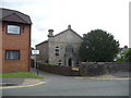
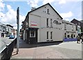
The Christian Temple, High Street, Ammanford
The date plaque states that a chapel was sited here in 1782, rebuilt in 1836 and extended or enlarged in 1865.
The building is set off by a Yew tree.
For a fascinating external link to local chapels see: [http://www.terrynorm.ic24.net/christian%20temple.htm]
Image: © Jeremy Bolwell
Taken: 4 Jun 2012
0.05 miles
3
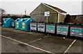
Recycling area in a corner of a town centre car park, Ammanford
The bilingual (Welsh & English) Carmarthenshire County Council notice states that this area is covered by CCTV. Only items inside containers will be recycled. Items left around the containers will be deemed to have been illegally deposited. Offenders may incur a fixed penalty fine, or face prosecution at court.
Image: © Jaggery
Taken: 11 Feb 2015
0.06 miles
4
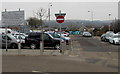
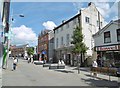
Town centre pay & display car park, Ammanford
The Carmarthenshire County Council car park is accessed from Margaret Street.
Image: © Jaggery
Taken: 11 Feb 2015
0.09 miles
5
Ammanford, Old Cross Inn
Public house at the corner of Quay Street and High Street. Bar left, drinking areas front, back; games machine, TV, darts, pool. No cask ale available.
Image: © Mike Faherty
Taken: 14 Jul 2016
0.10 miles
6
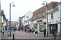
Quay Street, Ammanford (Recreated)
Looking north up Quay St, from near the junction with Hall St and angled towards the east side.
This is a recreation of the 1965 photo at Frith: http://www.francisfrith.com/search/wales/dyfed/ammanford/photos/ammanford_A186091.htm
The street is now pedestrianised, and the terraced red brick buildings in the extreme distance have had their pinnacled dormer windows removed when the roof was replaced.
Image: © Nigel Davies
Taken: 24 Dec 2006
0.10 miles
7
Fresh Bites in Ammanford
Takeaway near Ammanford bus station, selling baguettes, sandwiches, jacket potatoes etc.
Image: © Jaggery
Taken: 11 Feb 2015
0.10 miles
8
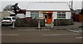
Ammanford Post Office
Surviving Crown post office on Quay Street.
Image: © Mike Faherty
Taken: 14 Jul 2016
0.11 miles
9
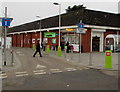
The Co-operative Food Store in Ammanford
Located at the edge of Ammanford bus station.
Image: © Jaggery
Taken: 11 Feb 2015
0.11 miles
10
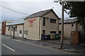
Canolfan Aman Centre
Former Great War drill hall, base for H Company, 4th Battalion Welch Regiment in 1914.
Image: © John M
Taken: 3 Apr 2015
0.11 miles