IMAGES TAKEN NEAR TO
Wernoleu Road, AMMANFORD, SA18 2JH
Introduction
This page details the photographs taken nearby to Wernoleu Road, SA18 2JH by members of the Geograph project.
The Geograph project started in 2005 with the aim of publishing, organising and preserving representative images for every square kilometre of Great Britain, Ireland and the Isle of Man.

There are currently over 7.5m images from over14,400 individuals and you can help contribute to the project by visiting https://www.geograph.org.uk
Image Map (Loading...)


Getting Data...Please wait
Leaflet Map data © OpenStreetMap
Images are licensed for reuse under creativecommons.org/licenses/by-sa/2.0
Notes
- Clicking on the map will re-center to the selected point.
- The higher the marker number, the further away the image location is from the centre of the postcode.
Image Listing (4 Images Found)
Images are licensed for reuse under creativecommons.org/licenses/by-sa/2.0
Image
Details
Distance
1
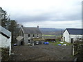
Bodist Uchaf
Remote farm on a windswept hillside.
Image: © Marion Phillips
Taken: 19 Jan 2010
0.02 miles
2
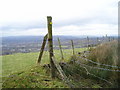
Fence crossing
The map marks this as a right of way, the yellow arrow confirms it but I needed to climb over the fence here.
Image: © Marion Phillips
Taken: 19 Jan 2010
0.21 miles
3
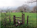
Llwybr Bodist Isaf / Bodist Isaf Path
Sticil ar lwybr cyhoeddus sy'n arwain at Ffarm Bodist Isaf sydd i'w gweld yn y pellter.
A stile on a public footpath heading towards Bodist Isaf Farm (trans. Ust's abode [lower farm]) visible in the distance.
Image: © Alan Richards
Taken: 25 Apr 2014
0.21 miles
4
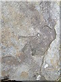
Ordnance Survey Rivet
This OS rivet can be found on a very large rock to the NW of the track. It marks a point 262.7224m above mean sea level.
Image: © Adrian Dust
Taken: 3 May 2014
0.25 miles