IMAGES TAKEN NEAR TO
Gwaun Henllan, AMMANFORD, SA18 2FD
Introduction
This page details the photographs taken nearby to Gwaun Henllan, SA18 2FD by members of the Geograph project.
The Geograph project started in 2005 with the aim of publishing, organising and preserving representative images for every square kilometre of Great Britain, Ireland and the Isle of Man.

There are currently over 7.5m images from over14,400 individuals and you can help contribute to the project by visiting https://www.geograph.org.uk
Image Map (Loading...)


Getting Data...Please wait
Leaflet Map data © OpenStreetMap
Images are licensed for reuse under creativecommons.org/licenses/by-sa/2.0
Notes
- Clicking on the map will re-center to the selected point.
- The higher the marker number, the further away the image location is from the centre of the postcode.
Image Listing (18 Images Found)
Images are licensed for reuse under creativecommons.org/licenses/by-sa/2.0
Image
Details
Distance
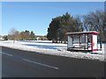
1
Upstream along the Loughor, Bonllwyn
The River Loughor flows towards the camera on the A483 road bridge http://www.geograph.org.uk/photo/4457804 north of Ammanford.
Image: © Jaggery
Taken: 1 May 2015
0.14 miles
2
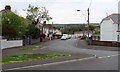
Myddynfych, Ammanford
Myddynfych is on the left, near the camera and ahead.
Old Road continues to the right of the lower right corner of the photo.
Image: © Jaggery
Taken: 1 May 2015
0.15 miles
3
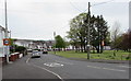
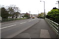
Myddynfych 20mph zone, Ammanford
Viewed from the corner of the A483 Llandybie Road. The 30mph speed limit reduces to 20 along Myddynfych.
Image: © Jaggery
Taken: 1 May 2015
0.18 miles
4
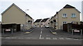
Clos Yr Afon, Bonllwyn near Ammanford
Cul-de-sac on the east side of the A483. The houses were built c2010.
Image: © Jaggery
Taken: 1 May 2015
0.18 miles
5
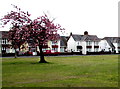
May Day pink blossom in Ammanford
One of many trees on a large green between Llandybie Road and Old Road (ahead) viewed on May 1st 2015.
Image: © Jaggery
Taken: 1 May 2015
0.19 miles
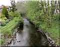
6
Road bridge over the River Loughor, Bonllwyn
North of Ammanford, the A483 crosses the bridge over the River Loughor. http://www.geograph.org.uk/photo/4457790 http://www.geograph.org.uk/photo/4457796
Image: © Jaggery
Taken: 1 May 2015
0.19 miles
7
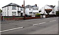
White houses, Bonllwyn
Viewed across the A483 north of Ammanford.
Image: © Jaggery
Taken: 1 May 2015
0.20 miles
8
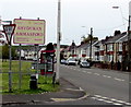
Welcome to Ammanford sign
The sign is alongside the A483 Llandybie Road at the northern edge of Ammanford.
It shows that Ammanford is twinned with Breuillet (northern France).
Image: © Jaggery
Taken: 1 May 2015
0.20 miles
9
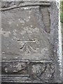
Ordnance Survey Cut Mark
This OS cut mark can be found on the house which was Bonclwyn Farm. It marks a point 44.2730m above mean sea level.
Image: © Adrian Dust
Taken: 24 Aug 2013
0.20 miles