IMAGES TAKEN NEAR TO
Lon Llwyd, AMMANFORD, SA18 2FA
Introduction
This page details the photographs taken nearby to Lon Llwyd, SA18 2FA by members of the Geograph project.
The Geograph project started in 2005 with the aim of publishing, organising and preserving representative images for every square kilometre of Great Britain, Ireland and the Isle of Man.

There are currently over 7.5m images from over14,400 individuals and you can help contribute to the project by visiting https://www.geograph.org.uk
Image Map (Loading...)


Getting Data...Please wait
Leaflet Map data © OpenStreetMap
Images are licensed for reuse under creativecommons.org/licenses/by-sa/2.0
Notes
- Clicking on the map will re-center to the selected point.
- The higher the marker number, the further away the image location is from the centre of the postcode.
Image Listing (10 Images Found)
Images are licensed for reuse under creativecommons.org/licenses/by-sa/2.0
Image
Details
Distance
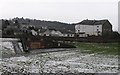
1
Cwmamman Road, Glanaman (Recreated)
This is a recreation of the following 1956 photo from the Frith collection: http://www.francisfrith.com/search/wales/powys/glanaman/photos/glanaman_G249020.htm
Image: © Nigel Davies
Taken: 6 Jan 2007
0.08 miles
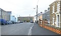
2
Bethesda Baptist Chapel, Glanamman
Another large chapel dating from 1842 initially. See: http://www.cwmammanhistory.co.uk/Amman_Valley_History/pages/Bethesda_Glanamman_c.1925.htm
Image: © Jeremy Bolwell
Taken: 4 Jun 2012
0.11 miles
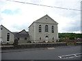
3
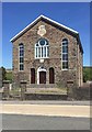
Bethel Chapel
Bethel Independent Chapel, Garnant.
Image: © Alan Hughes
Taken: 15 May 2018
0.11 miles
4
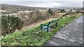
A bench with a view
Looking up the Amman Valley, the image was taken in Gelli Werdd Park - a converted coal tip.
Image: © Hywel Williams
Taken: 30 Jan 2022
0.12 miles
5
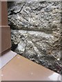
Ordnance Survey Cut Mark
This Ordnance Survey Cut Mark can be found partly hidden by a down pipe on the front of No 57 Cwmamman Road. It marks a point 98.5490m above mean sea level.
Image: © Adrian Dust
Taken: 20 Jun 2013
0.14 miles
6
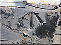
Ordnance Survey Rivet
This Ordnance Survey NBM can be found on the Window Sill of No 230 Cwmamman Road, Garnant. The Rivet seems to be missing but the Broad Arrow can be made out. It marks a point 107.3100m above mean sea level.
Image: © Adrian Dust
Taken: 6 Jun 2013
0.15 miles
7
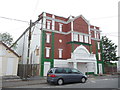
Cwmamman Public Hall, Garnant
A workingmen's hall or miner's institute. See [http://www.terrynorm.ic24.net/ammanford%20miners%20welfare.htm]
Image: © Jeremy Bolwell
Taken: 4 Jun 2012
0.16 miles
8
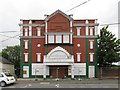
Cwmamman Workmen's Hall, Garnant
Here is a square-on view of the facade of the old hall pictured in Image
Barriers have now been erected to keep pedestrians away from the masonry which has started falling since that previous photo.
For a history of the hall and a photo before its windows were sealed up see http://www.cwmammanhistory.co.uk/Amman_Valley_History/pages/Cwmamman_Workmens_Hall.html
Image: © Nigel Davies
Taken: 9 Jul 2013
0.16 miles
9
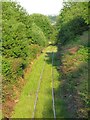
Amman valley mineral line
This is the view up the valley from the footbridge that crosses over the railway on the path out of Parc Golwg yr Aman.
The line is in only occasional use for transporting coal from Celtic Energy's open cast at East Pit. Image
Image: © Nigel Davies
Taken: 8 Jun 2013
0.19 miles
10
Multiwall in Parc Golwg yr Aman
This park was built on the site of old tinplate works. Pictured behind the rugby pitch is a multiwall, where it's suggested that virtually any ball game known to man can be played. Garnat workman's hall can be seen standing in the distance.
Image: © Hywel Williams
Taken: 10 Feb 2007
0.22 miles