IMAGES TAKEN NEAR TO
Maesyrhendre, AMMANFORD, SA18 2BW
Introduction
This page details the photographs taken nearby to Maesyrhendre, SA18 2BW by members of the Geograph project.
The Geograph project started in 2005 with the aim of publishing, organising and preserving representative images for every square kilometre of Great Britain, Ireland and the Isle of Man.

There are currently over 7.5m images from over14,400 individuals and you can help contribute to the project by visiting https://www.geograph.org.uk
Image Map (Loading...)


Getting Data...Please wait
Leaflet Map data © OpenStreetMap
Images are licensed for reuse under creativecommons.org/licenses/by-sa/2.0
Notes
- Clicking on the map will re-center to the selected point.
- The higher the marker number, the further away the image location is from the centre of the postcode.
Image Listing (9 Images Found)
Images are licensed for reuse under creativecommons.org/licenses/by-sa/2.0
Image
Details
Distance
1
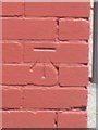
Ordnance Survey Bench Mark
This Ordnance Survey Cut NBM can be found on the NW Face, SE Angle of No 36 Maes Yr Hendre, Garnant. It is 110.9840m above sea level.
Image: © Adrian Dust
Taken: 6 Jun 2013
0.09 miles
2
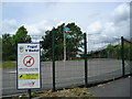
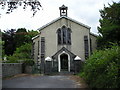
Ysgol y Bedol
Behave yourself and stick to the rules!
Image: © Marion Phillips
Taken: 6 Jul 2010
0.15 miles
4
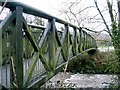
Footbridge to park in Garnant
This bridge across the Aman river leads from a car park into Parc Golwg yr Afon.
Image: © Nigel Davies
Taken: 10 Feb 2007
0.19 miles
5
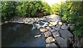
Weir on the Aman
Looking upstream from a viewing platform in Parc Golwg yr Aman.
Image: © Nigel Davies
Taken: 8 Jun 2013
0.20 miles
7
Multiwall in Parc Golwg yr Aman
This park was built on the site of old tinplate works. Pictured behind the rugby pitch is a multiwall, where it's suggested that virtually any ball game known to man can be played. Garnat workman's hall can be seen standing in the distance.
Image: © Hywel Williams
Taken: 10 Feb 2007
0.22 miles
8
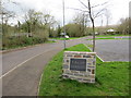
Y Palais, Garnant
Llwybr seiclo yn mynd heibio i hen safle Palais de Danse sef neuadd a agorwyd yn 1923 er cynnal dawnsfeydd, cyngerddau a ffilmiau. Yn ystod y 1950au a'r 1960au roedd y lle yn boblogaidd iawn gyda phobl ifanc yr ardal fel neuadd ddawnsio. Cyn cau bu'r adeilad hefyd yn ffatri jins a gweithdy ceir. Fe'i dymchwelwyd yn 2011 ac mae safle bellach yn faes parcio a safle bicnig.
A cycle track passing the site of the former Palais de Danse, a hall which opened in 1923 as a venue for dancing, concerts and for watching films. In its heyday during the 1950s and 60s the place was very popular with young people as a dance hall. Prior to its closure the building was also used as a jeans factory and as a car workshop. Demolished in 1911 the site is today a car park and a picnic site.
Image: © Alan Richards
Taken: 24 Apr 2014
0.23 miles
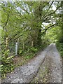
9
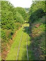
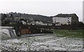
Amman valley mineral line
This is the view up the valley from the footbridge that crosses over the railway on the path out of Parc Golwg yr Aman.
The line is in only occasional use for transporting coal from Celtic Energy's open cast at East Pit. Image
Image: © Nigel Davies
Taken: 8 Jun 2013
0.24 miles