IMAGES TAKEN NEAR TO
College Street, AMMANFORD, SA18 2BR
Introduction
This page details the photographs taken nearby to College Street, SA18 2BR by members of the Geograph project.
The Geograph project started in 2005 with the aim of publishing, organising and preserving representative images for every square kilometre of Great Britain, Ireland and the Isle of Man.

There are currently over 7.5m images from over14,400 individuals and you can help contribute to the project by visiting https://www.geograph.org.uk
Image Map (Loading...)


Getting Data...Please wait
Leaflet Map data © OpenStreetMap
Images are licensed for reuse under creativecommons.org/licenses/by-sa/2.0
Notes
- Clicking on the map will re-center to the selected point.
- The higher the marker number, the further away the image location is from the centre of the postcode.
Image Listing (125 Images Found)
Images are licensed for reuse under creativecommons.org/licenses/by-sa/2.0
Image
Details
Distance
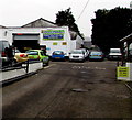
1
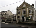
Eglwys y Gwynfryn, Ammanford
Independent church on the west side of College Street. The information board is in Welsh only.
Image: © Jaggery
Taken: 11 Feb 2015
0.02 miles
2
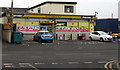
A-Z Convenience Store in Ammanford
Premier convenience store at 110 College Street, opposite Bryn Mawr Avenue.
Image: © Jaggery
Taken: 11 Feb 2015
0.06 miles
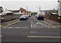
3
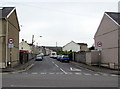
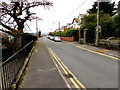
Talbot Road, Ammanford
Viewed from Station Road. A 7.5 tonnes vehicle weight limit applies ahead, except for access.
Image: © Jaggery
Taken: 1 May 2015
0.07 miles
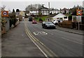
4
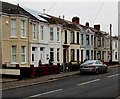
Houses at the NW end of College Street, Ammanford
Located near the Station Road junction where the A483 Llandybie Road
behind the camera becomes the A483 College Street ahead.
Image: © Jaggery
Taken: 11 Feb 2015
0.07 miles
5
Entrance to Marc's Motors in Ammanford
From Station Road, opposite Harold Street.
Image: © Jaggery
Taken: 11 Feb 2015
0.07 miles
6
Brynteg Terrace, Ammanford
Viewed across the A483 College Street looking along Brynteg Terrace towards Talbot Road.
Image: © Jaggery
Taken: 11 Feb 2015
0.08 miles
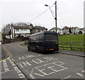
7
20 along Bryn Mawr Avenue, Ammanford
The 30mph speed limit along the A483 College Street reduces to 20 along Bryn Mawr Avenue.
Image: © Jaggery
Taken: 11 Feb 2015
0.08 miles
8
Ammanford Bus Hire vehicle in Bryn Mawr Avenue, Ammanford
Parked near the entrance to Brynteg Surgery and Lloyds Pharmacy. http://www.geograph.org.uk/photo/4346542
Image: © Jaggery
Taken: 11 Feb 2015
0.08 miles
10
NNW along Bryn Mawr Avenue, Ammanford
The railings and gate on the right are at the edge of All Saints. http://www.geograph.org.uk/photo/4346575
Image: © Jaggery
Taken: 11 Feb 2015
0.08 miles