IMAGES TAKEN NEAR TO
Tyle Glas, AMMANFORD, SA18 1XY
Introduction
This page details the photographs taken nearby to Tyle Glas, SA18 1XY by members of the Geograph project.
The Geograph project started in 2005 with the aim of publishing, organising and preserving representative images for every square kilometre of Great Britain, Ireland and the Isle of Man.

There are currently over 7.5m images from over14,400 individuals and you can help contribute to the project by visiting https://www.geograph.org.uk
Image Map
Images are licensed for reuse under creativecommons.org/licenses/by-sa/2.0
Notes
- Clicking on the map will re-center to the selected point.
- The higher the marker number, the further away the image location is from the centre of the postcode.
Image Listing (5 Images Found)
Images are licensed for reuse under creativecommons.org/licenses/by-sa/2.0
Image
Details
Distance
1
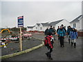
Tai newydd / new houses
Mae cae gyda llwybr cyhoeddus wedi cael ei ddisodli gan dai ac hewl.
A field with a public footpath has been replaced by new houses and a road.
Image: © Alan Richards
Taken: 30 Jan 2005
0.09 miles
2
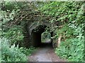
Railway underpass in Glangarnant
The footpath that crosses the Garnant river has to pass under the valley railway.
Image: © Nigel Davies
Taken: 9 Jun 2013
0.22 miles
3
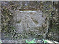
Ordnance Survey Cut Mark
This Ordnance Survey NBM Cut Mark can be found on the NW Buttress, SW Face of the Railway Bridge over the A474 and Cwm Garnant. It marks a point 123.5590m above mean sea level.
Image: © Adrian Dust
Taken: 6 Jun 2013
0.23 miles
4
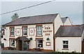
The Raven Inn, Garnant
This is a recreation of the old photo seen on the following page:
http://freepages.history.rootsweb.ancestry.com/~cwmgors/Garnant5.html http://web.archive.org/web/20111011222354/http://www.tytwp.plus.com/Waun/Garnant5.html
The chimneys are gone and the pub name is no longer painted on the window glass but on a swinging sign together with lettering on the wall. An entrance porch is also a more recent addition.
Image: © Nigel Davies
Taken: 11 Oct 2011
0.24 miles
5
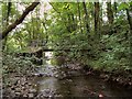
Glangarnant footbridge
This bridge is on a footpath that joins the main road south of the Garnant river to Neuadd Road on the north of the river.
For a 1930's view of this bridge see http://www.cwmammanhistory.co.uk/Amman_Valley_History/pages/Glangarnant_Footbridge.html
Image: © Nigel Davies
Taken: 9 Jun 2013
0.24 miles