IMAGES TAKEN NEAR TO
New Road, AMMANFORD, SA18 1UP
Introduction
This page details the photographs taken nearby to New Road, SA18 1UP by members of the Geograph project.
The Geograph project started in 2005 with the aim of publishing, organising and preserving representative images for every square kilometre of Great Britain, Ireland and the Isle of Man.

There are currently over 7.5m images from over14,400 individuals and you can help contribute to the project by visiting https://www.geograph.org.uk
Image Map
Images are licensed for reuse under creativecommons.org/licenses/by-sa/2.0
Notes
- Clicking on the map will re-center to the selected point.
- The higher the marker number, the further away the image location is from the centre of the postcode.
Image Listing (15 Images Found)
Images are licensed for reuse under creativecommons.org/licenses/by-sa/2.0
Image
Details
Distance
2
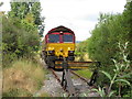
End of the line in Gwaun-cae-Gurwen
Class 66 No. 66187 runs around its train at Gwaun-cae-Gurwen. Here the wagons will be loaded with coal before returning to Swansea Burrows.
Image: © Gareth James
Taken: 12 Jul 2018
0.07 miles
3

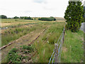
Level Crossing
This railway line is still considered in use, though practically a lot of work would be needed to bring it back into service (work that's underway since the picture was taken). Up until the early 1990s, coal trains would be run up from Betws Colliery near Ammanford to the washeries that still ran here. When the washeries closed, the railway line was left to decay.
Image: © Hywel Williams
Taken: 24 Aug 2003
0.09 miles
4
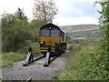
The end of the line
A locomotive stops at the end of the Amman Valley mineral railway - it's a short stop however as it's about to travel along a loop to allow it to be positioned at the other end of a train of coal wagons currently being loaded by diggers.
There is evidence on a nearby road that this railway used to continue further along. This is remembered by locals as a line to serve nearby mines and one historic Ordnance Survey map seems to suggest a through connection to Cwmllynfell - however there's no argument that it stops here now!
Image: © Hywel Williams
Taken: 28 Apr 2009
0.12 miles
5
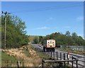
Tairgwaith opencast mine
KCS delivery lorry arriving at East Pit opencast mine, Tairgwaith.
Image: © Alan Hughes
Taken: 15 May 2018
0.13 miles
6
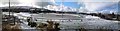
Tairgwaith Trotting Track
Wintry panorama of Tairgwaith trotting track, built on land reclaimed from the Maerdy & Steer deep mine's spoil heaps.
Image: © Anonymous
Taken: 21 Feb 2010
0.15 miles
7
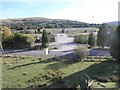
Last remains of rail marshaling yard
The concrete waste in the foreground at one time used to be a large rail marshaling yard to serve nearby coal yards and coal washery. Today, only a single railway line runs through the yard - recently refurbished for a reason that seems now to have vanished as the proposed coal treatment centre to be built here is no longer being built.
in the distance, part of the oval of the horse trotting track can be seen.
Image: © Hywel Williams
Taken: 4 Oct 2007
0.17 miles
8
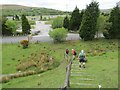
Llwybr Tairgwaith Path
Llwybr yn arwain at bentre Tairgwaith. Gerllaw gellir gweld Trac Trotio Dyffryn Aman a sefydlwyd yn 1979 ar safle dwy lofa sef y Maerdy (1866-1948) a'r Steer (1922-1959). Mynydd Uchaf yw'r bryn a welir yn y pellter.
A footpath leading to the village of Tairgwaith. Nearby, one can see the Aman Valley Trotting Course established in 1979 on the site of two collieries, Maerdy Pit (1866-1948) and the Steer Pit (1922-1959). The hill in the distance is known as Mynydd Uchaf.
Image: © Alan Richards
Taken: 2 Jun 2013
0.18 miles
9
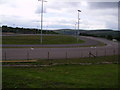
Trotting track
The harness racing track at Tairgwaith
Image: © Geraint Smith
Taken: 17 May 2008
0.19 miles