IMAGES TAKEN NEAR TO
Maes-y-Deri, AMMANFORD, SA18 1TA
Introduction
This page details the photographs taken nearby to Maes-y-Deri, SA18 1TA by members of the Geograph project.
The Geograph project started in 2005 with the aim of publishing, organising and preserving representative images for every square kilometre of Great Britain, Ireland and the Isle of Man.

There are currently over 7.5m images from over14,400 individuals and you can help contribute to the project by visiting https://www.geograph.org.uk
Image Map (Loading...)


Getting Data...Please wait
Leaflet Map data © OpenStreetMap
Images are licensed for reuse under creativecommons.org/licenses/by-sa/2.0
Notes
- Clicking on the map will re-center to the selected point.
- The higher the marker number, the further away the image location is from the centre of the postcode.
Image Listing (20 Images Found)
Images are licensed for reuse under creativecommons.org/licenses/by-sa/2.0
Image
Details
Distance
1
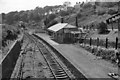
Brynamman West Station
View westward, towards Pantyfynnon; terminus of ex-Great Western branch from Pantyfynnon, closed to passengers 18/8/58, to goods (from Garnant 28/9/64).
The station seems to have been still in good order in 1962.
Image: © Ben Brooksbank
Taken: 1 Jun 1962
0.08 miles
2
Club Rygbi Brynaman
Brynaman Rugby Club.
Image: © Alan Hughes
Taken: 15 Aug 2019
0.14 miles
3
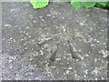
Ordnance Survey Rivet with arrow
This OS Rivet with arrow can be found on the west parapet of the road bridge over the River Amman. It marks a point 146.1000m above mean sea level.
Image: © Adrian Dust
Taken: 4 Jul 2013
0.15 miles
5
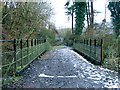
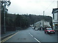
Former rail bridge, Lower Brynaman
A long gone railway line is now a path and access to houses.
Image: © Nigel Davies
Taken: 10 Feb 2007
0.15 miles
6
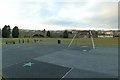
Park in Brynamman
A football pitch and playground in a single enclosure.
Image: © Nigel Davies
Taken: 3 Mar 2013
0.15 miles
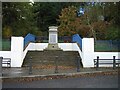
8
Former station, Brynamman (Recreated)
This is a recreation of the 1960 photo from the Frith collection, found here: http://www.francisfrith.com/search/wales/dyfed/upper+brynamman/photos/upper+brynamman_U37031.htm
The stations and railway lines are now gone. Curiously, what might appear to be one continuous railway line on the old maps isn't.
There were two separate lines that never met and two marked stations, one each side of this road.
Image: © Nigel Davies
Taken: 6 Jan 2007
0.17 miles
9
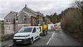
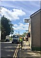
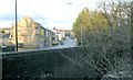
Road closure at Lower Brynamman
An old coal mine recently opened up under and beside the road. The road is going to be closed for at least three weeks to make it safe again. The closure is having a major impact on the narrow lanes in the vicinity which are now carrying most of the traffic from this busy A road.
Image: © Sandy Gerrard
Taken: 3 Apr 2024
0.17 miles
10
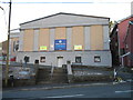
Brynamman Public Hall and Institute
Opened on 15th May 1926 this building is home to the Brynamman Public Hall Cinema
Image: © Sandy Gerrard
Taken: 26 Oct 2004
0.17 miles