IMAGES TAKEN NEAR TO
Park Howard Road, AMMANFORD, SA18 1PA
Introduction
This page details the photographs taken nearby to Park Howard Road, SA18 1PA by members of the Geograph project.
The Geograph project started in 2005 with the aim of publishing, organising and preserving representative images for every square kilometre of Great Britain, Ireland and the Isle of Man.

There are currently over 7.5m images from over14,400 individuals and you can help contribute to the project by visiting https://www.geograph.org.uk
Image Map
Images are licensed for reuse under creativecommons.org/licenses/by-sa/2.0
Notes
- Clicking on the map will re-center to the selected point.
- The higher the marker number, the further away the image location is from the centre of the postcode.
Image Listing (10 Images Found)
Images are licensed for reuse under creativecommons.org/licenses/by-sa/2.0
Image
Details
Distance
1
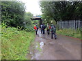
Tuag at Gelli Fawr / Towards Gelli Fawr
Cerddwyr yn dilyn heol sy'n arwain at anhedd-dy o'r enw Gelli Fawr. Cludai'r bont yn y pellter reilffordd a ai at hen Lofa Abernant.
Walkers following a road to a property known as Gelli Fawr (trans. big grove). The bridge in the distance carried the mineral railway to the former Abernant Colliery (trans. confluence of the stream)
Image: © Alan Richards
Taken: 12 Aug 2018
0.07 miles
2
Llwybr Cwmgors / Cwmgors Path
Llwybr cyhoeddus yn arwain at yr A474 yng Nghwmgors.
A public footpath heading towards the A474 in Cwmgors.
Image: © Alan Richards
Taken: 21 Feb 2020
0.11 miles
3
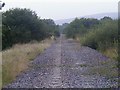
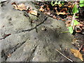
Dismantled Railway Line
This dismantled railway line ran as a branch of the Pantyfynnon to Gwaun Cae Guwen line and served the Abernant colliery. When this closed in 1988, the railway was no longer required and the tracks were soon lifted for recycling.
Image: © Hywel Williams
Taken: 24 Aug 2003
0.12 miles
4
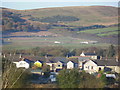
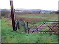
Park Howard pony club, Cwmgors
Taken from the site of the old Cwmgors brick works.
Image: © Geraint Smith
Taken: 4 Nov 2006
0.13 miles
5
Ordnance Survey Rivet
This OS Rivet, with arrow, can be found on the parapet of the road bridge over Cwm Garnant in Gwaun-Cae-Gurwen. It marks a point 152.1287m above mean sea level.
Image: © Adrian Dust
Taken: 29 Jun 2013
0.15 miles
6
Llwybr Cwmgors / Cwmgors path
Llwybr cyhoeddus yng Nghwmgors.
A public footpath in Cwmgors (trans. valley of marshy ground).
Image: © Alan Richards
Taken: 21 Feb 2020
0.16 miles
7
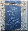
Turn-Pike Tollgate Plaque
This plaque can be found on the Funeral Directors east side of the road.
Image: © Adrian Dust
Taken: 14 May 2020
0.22 miles
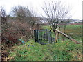
8
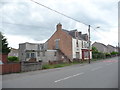
The old RAOB Club, Gwaun-Cae-Gurwen
The Royal Antediluvian Order of Buffaloes club has seen better days.
Image: © Jeremy Bolwell
Taken: 4 Jun 2012
0.24 miles
9
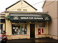
Gwaun Cae Gurwen: the post office
Looking through heavy rain at the frontage of the post office. Hyphens or spaces between the words of the placename seem equally acceptable.
Image: © Chris Downer
Taken: 21 Aug 2010
0.24 miles
10
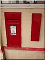
Gwaun Cae Gurwen: postbox № SA18 282
This George V-reign postbox is set into the wall of Image and is emptied finally at 5pm on weekdays and at 11am on Saturdays. Alongside is what I assume is a former stamp vending machine.
Image: © Chris Downer
Taken: 21 Aug 2010
0.24 miles