IMAGES TAKEN NEAR TO
Garnant, AMMANFORD, SA18 1JP
Introduction
This page details the photographs taken nearby to SA18 1JP by members of the Geograph project.
The Geograph project started in 2005 with the aim of publishing, organising and preserving representative images for every square kilometre of Great Britain, Ireland and the Isle of Man.

There are currently over 7.5m images from over14,400 individuals and you can help contribute to the project by visiting https://www.geograph.org.uk
Image Map (Loading...)


Getting Data...Please wait
Leaflet Map data © OpenStreetMap
Images are licensed for reuse under creativecommons.org/licenses/by-sa/2.0
Notes
- Clicking on the map will re-center to the selected point.
- The higher the marker number, the further away the image location is from the centre of the postcode.
Image Listing (3 Images Found)
Images are licensed for reuse under creativecommons.org/licenses/by-sa/2.0
Image
Details
Distance
1
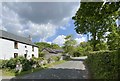
Llandeilo Road
A house on the old road from Llandeilo to Brynaman.
Image: © Alan Hughes
Taken: 4 May 2020
0.11 miles
2
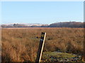
Llwybr Cwm Aman Footpath
Mae'r llwybr cyhoeddus yn arwain drwy'r brwyn at Barc Natur Ynys Dawela. Gan amlaf porir y tir gan dda ac mae'r postyn, wrth ei siap, wedi bod yn gyfleus iawn i rwto yn ei erbyn.
The footpath leads through the rushes towards Ynys Dawela Nature Reserve. The field is usually grazed by cattle and judging by the shape of the waymarker it has become a very convenient rubbing post.
Image: © Alan Richards
Taken: 5 Dec 2010
0.15 miles
3
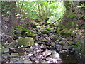
Nant Gwinau
It is July and there is not much water in the stream at the moment, but the rounded boulders show that sometimes a great deal of water comes down off the moors.
Image: © Marion Phillips
Taken: 6 Jul 2010
0.23 miles