IMAGES TAKEN NEAR TO
Waun Leision, AMMANFORD, SA18 1ER
Introduction
This page details the photographs taken nearby to Waun Leision, SA18 1ER by members of the Geograph project.
The Geograph project started in 2005 with the aim of publishing, organising and preserving representative images for every square kilometre of Great Britain, Ireland and the Isle of Man.

There are currently over 7.5m images from over14,400 individuals and you can help contribute to the project by visiting https://www.geograph.org.uk
Image Map
Images are licensed for reuse under creativecommons.org/licenses/by-sa/2.0
Notes
- Clicking on the map will re-center to the selected point.
- The higher the marker number, the further away the image location is from the centre of the postcode.
Image Listing (22 Images Found)
Images are licensed for reuse under creativecommons.org/licenses/by-sa/2.0
Image
Details
Distance
1
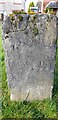
Old Milestone by the A4069 in Gwaun-Cae-Gurwen
This old milestone is on the west of the A4069 on a wide grass verge between the A road and Maesywerin. Old-maps up to 1953 show the MS on the opposite side of the road.
Inscription unclear but once read:- : (LLANGADOCK 14 / NEATH 11) :
Milestone Society National ID: GLA_NTLG11
Image: © Kirstie Hackett
Taken: 28 Jan 2020
0.09 miles
2
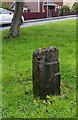
Milestone - Neath 11, Llangadog 14
West side of road.
Image: © Adrian Dust
Taken: 3 Sep 2017
0.10 miles
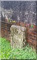
4
Old Milestone by the A474 in Gwaun-Cae-Gurwen
This old milestone is on the north east side of the A474, against a low brick wall, behind a grass verge.
Inscription reads:- : XI / NEATH :
Milestone Society National ID: GLA_NTLO11
Image: © Kirstie Hackett
Taken: 28 Jan 2020
0.11 miles
5
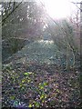
Gwaun-Cae-Gurwen Incline
Tramway leading to the railway via an incline on the south side of the valley
Image: © Anthony Gostling
Taken: 4 Apr 2010
0.14 miles
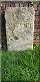
6
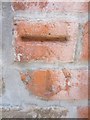
Ordnance Survey Cut Mark
This damaged OS Cut Mark can be found on the front of NO2 Graig Road. It marks a point 158.5650m above mean sea level.
Image: © Adrian Dust
Taken: 29 Jun 2013
0.15 miles
7
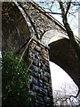
Gwaun-Cae-Gurwen Viaduct
A four-arch viaduct bridge was built, but it was never used.
Image: © Anthony Gostling
Taken: 4 Apr 2010
0.16 miles
9
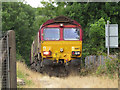
Freight train at Gwaun-cae-Gurwen
Class 66 No. 66187 approaches the level crossing at Gwaun-cae-Gurwen with a train of empty coal wagons from Swansea Burrows.
Image: © Gareth James
Taken: 12 Jul 2018
0.17 miles
10
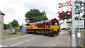
Level crossing in Gwaun-cae-Gurwen
Class 66 No. 66187 crosses the A474 in Gwaun-cae-Gurwen with coal empties from Swansea Burrows.
Image: © Gareth James
Taken: 12 Jul 2018
0.17 miles