IMAGES TAKEN NEAR TO
Caernarvon Way, SWANSEA, SA1 7HL
Introduction
This page details the photographs taken nearby to Caernarvon Way, SA1 7HL by members of the Geograph project.
The Geograph project started in 2005 with the aim of publishing, organising and preserving representative images for every square kilometre of Great Britain, Ireland and the Isle of Man.

There are currently over 7.5m images from over14,400 individuals and you can help contribute to the project by visiting https://www.geograph.org.uk
Image Map (12 Images)


Getting Data...Please wait
Leaflet Map data © OpenStreetMap
Images are licensed for reuse under creativecommons.org/licenses/by-sa/2.0
Notes
- Clicking on the map will re-center to the selected point.
- The higher the marker number, the further away the image location is from the centre of the postcode.
Image Listing (12 Images Found)
Images are licensed for reuse under creativecommons.org/licenses/by-sa/2.0
Image
Details
Distance
2
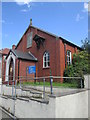
St Margaret's Church
There is an Ordnance Survey cut mark on the west angle. http://www.geograph.org.uk/photo/4642869
Image: © Adrian Dust
Taken: 1 Sep 2015
0.09 miles
3
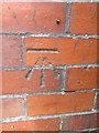
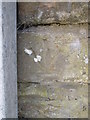
Ordnance Survey Cut Mark
This OS cut mark can be found on the west angle of St Margaret's Church. It marks a point 87.746m above mean sea level. http://www.geograph.org.uk/photo/4642871
Image: © Adrian Dust
Taken: 1 Sep 2015
0.09 miles
4
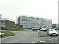
Cefn Hengoed School & Leisure Centre, Bonymaen
These distinctive blocks perched atop Bonymaen hill are visible from quite some distance.
Image: © Nigel Davies
Taken: 22 Sep 2008
0.12 miles
5
Ordnance Survey Cut Mark
This OS cut mark can be found on No19 Cwm Chapel Road. It marks a point 72.872m above mean sea level.
Image: © Adrian Dust
Taken: 22 Oct 2020
0.12 miles
6
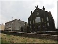
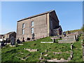
Capel Salem (Capel y Cwm), Bonymaen
Cyn adeiladu'r capel cyntaf yn 1782 addolai'r Methodistiad lleol mewn ffermdai ac anhedd-dai cyfagos. Helaethwyd y capel yn 1823 ac maen bosibl i'r addoldy presennol adfeiliedig ddyddio o 1870. Ar un adeg yn flynyddol cynhelid gwasanaeth y Plygain yn gynnar iawn ar fore'r Nadolig yng Nghapel y Cwm. Yn 1903-05 codwyd capel newydd sbond drws nesaf am £7,000. Un o uchafbwyntiau y flwyddyn oedd y cyngerdd blynyddol lle canai cor mawr y capel oriatorios poblogaidd. Yn anffodus, ychydig o flynyddoedd yn ol fel y gwelir, dinistriwyd yr hen gapel gan dân.
Before erecting the first chapel in 1782 local Methodists met at various farmhouses and cottages. This chapel was enlarged in 1823 and it is possible that the present ruined meeting house was built in 1870. At one time a very early morning Christmas service called a 'Plygain' was held annually at Capel y Cwm. In 1903-05 a brand new chapel was built alongside the old at a cost of £7,000. One of the highlights of the year was the annual concert where the large chapel choir sang popular oratorios Tragically, a few years ago, as one can see, the old chapel was completely gutted by fire.
Image: © Alan Richards
Taken: 28 Mar 2013
0.17 miles
7
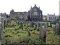
Mynwent Capel y Cwm / Capel y Cwm burial ground
Capel y Cwm, addoldy'r Methodistiad Calfinaidd fel y'i gwelir o'r fynwent.
Capel y Cwm Methodist Chapel as seen from the burial ground.
Image: © Alan Richards
Taken: 3 Apr 2019
0.18 miles
8
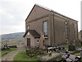
Capel Adulam / Adulam Chapel
Cyn codi Capel Adulam yn 1850 addolai Bedyddwyr yr ardal mewn annedd-dy o'r enw Ty Draw. Yn ôl y parchedig W. Samlet Williams cynhaliwyd yr eisteddfod cyntaf ym mhlwyf Llansamlet ym mynwent y capel. Roedd côr y capel yn adnabyddus am ei oratorios. Saif y capel ar dir uchel a chyferbyn y safai yr hen felin wynt (neu 'bili wynt' fel y'i gelwid) a ddymchwelyd gan Gyngor Sir Abertawe yn y 1960au er mwyn codi cronfa ddwr ddanddaearol. Yswaeth, nid oedd gan y cyngor y weledigaeth i'w hail-leoli.
Before the construction of Adulam Chapel in 1850 local Baptists worshipped at nearby Ty Draw, a large residence. According to the reverend W. Samlet Williams the first ever eisteddfod within the parish of Llamsamlet was held here. The chapel choir was also well known for its oriatorios. The chapel stands on a high ridge and opposite stood the old windmill or 'felin wynt or bili wynt' as it was known locally. Sadly, to make way for an underground reservoir this monument was demolished during the 1960s by Swansea Council who didn't have the foresight to have it relocated.
Image: © Alan Richards
Taken: 28 Mar 2013
0.22 miles
9
Mynwent Adulam / Adulam burial ground
Mynwent Capel Adulam, addoldy'r Bedyddwyr.
Burial ground of Adulam Baptist Chapel.
Image: © Alan Richards
Taken: 1 Apr 2019
0.22 miles
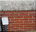
10
Ordnance Survey Cut Mark
This inverted OS cut mark can be found on the wall of No168 Jersey Road. It marks a point 54.565m above mean sea level.
Image: © Adrian Dust
Taken: 1 Sep 2015
0.23 miles