IMAGES TAKEN NEAR TO
Morris Drive, SWANSEA, SA1 7EG
Introduction
This page details the photographs taken nearby to Morris Drive, SA1 7EG by members of the Geograph project.
The Geograph project started in 2005 with the aim of publishing, organising and preserving representative images for every square kilometre of Great Britain, Ireland and the Isle of Man.

There are currently over 7.5m images from over14,400 individuals and you can help contribute to the project by visiting https://www.geograph.org.uk
Image Map (Loading...)


Getting Data...Please wait
Leaflet Map data © OpenStreetMap
Images are licensed for reuse under creativecommons.org/licenses/by-sa/2.0
Notes
- Clicking on the map will re-center to the selected point.
- The higher the marker number, the further away the image location is from the centre of the postcode.
Image Listing (11 Images Found)
Images are licensed for reuse under creativecommons.org/licenses/by-sa/2.0
Image
Details
Distance
1
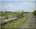
The remains of Upper Bank Station, Swansea
In this 1998 view, the decaying remains of Upper Bank Station can be seen. Upper Bank was opened in 1871 as part of the Swansea Vale Railway's route to Morriston. It eventually reached Brynamman. The whole line was taken over by the Midland Railway in 1876 and additional through routes were added as a result. Passenger services ceased in 1950 and complete closure took place in the 1960s.
By 1985 the only railway here was the section preserved by the SVR Society. In 2007, Swansea Council decided to redevelop the area and by 2010 the preserved railway was itself history, although the society itself lives on.
Image: © vectorkraft
Taken: 8 May 1998
0.07 miles
2
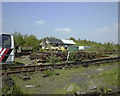
The yard and signal box at Swansea Vale Railway
This 1998 view shows the main yard used by the Swansea Vale Railway Society who ran a preserved line from Upper Bank to Six Pit Junction. The signal box was vandalised often and at the time of the visit was showing the scars of a recent arson attack.
The Swansea Vale Railway originally ran from Swansea St Thomas to Brynamman. It was taken over by the Midland Railway in 1876 and additional through routes were added as a result. Passenger services ceased in 1950 and complete closure took place in the 1960s.
By 1985 the only railway here was the section preserved by the SVR Society. In 2007, Swansea Council decided to redevelop the area and by 2010 the preserved railway was itself history, although the society itself lives on.
Image: © vectorkraft
Taken: 8 May 1998
0.09 miles
3
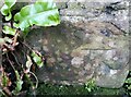
Ordnance Survey Cut Mark
This OS cut mark can be found on the rear wall of No56 Pentre-chwyth Road. It marks a point 41.297m above mean sea level.
Image: © Adrian Dust
Taken: 5 Jan 2021
0.10 miles
4
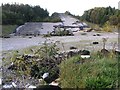
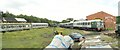
Disused dry ski slope
This used to be a popular dry ski slope. It now lies derelict, stripped of its special surface.
Image: © Hywel Williams
Taken: 15 Oct 2006
0.18 miles
5
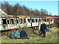
Rheilffordd Swansea Vale Railway
Cerddwyr yn Rheilffordd Swansea Vale, lle mae'r cerbydau, a oedd yn cael eu hadnewyddu'n ofalus gan griw bach o gwirfoddolwyr ymroddgar, wedi cael eu fandaleiddo a'u dodi ar dân.
Walkers at the Swansea Vale Railway where carriages, which were at the time being carefully restored by a small dedicated band of volunteers, have been vandalised and seriously damaged by fire.
Image: © Alan Richards
Taken: 28 Dec 2008
0.21 miles

7
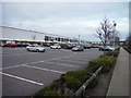
Swansea : Morfa Retail Park
Morfa Retail Park outside of Swansea city centre.
Image: © Lewis Clarke
Taken: 1 Mar 2014
0.22 miles
8
Swansea Vale Rail Yard
The small Swansea Vale railway is being restored here at the south end of the line.
Image: © Nigel Davies
Taken: 31 Jul 2005
0.23 miles
9
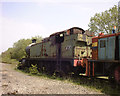
Rusting GWR locomotive at Swansea Vale Railway
This 1998 view shows the ex-GWR 2-8-0T locomotive stabled at one of Swansea Vale Railway's sidings. As of 2011, the loco is undergoing restoration at the Gloucestershire Warwickshire Railway (GWSR).
The Swansea Vale Railway originally ran from Swansea St Thomas to Brynamman. It was taken over by the Midland Railway in 1876 and additional through routes were added as a result. Passenger services ceased in 1950 and complete closure took place in the 1960s.
By 1985 the only railway here was the section preserved by the SVR Society. In 2007, Swansea Council decided to redevelop the area and by 2010 the preserved railway was itself history, although the society itself lives on.
Image: © vectorkraft
Taken: 8 May 1998
0.24 miles
10
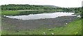
The Pluck
Just across the road from Morrisons and the old dry ski slope lies this lake. There are paths around it and it is near community woodland.
The lake is rumoured to be home to a crocodile or alligator "The Pluck Ness Monster" (!!) but judging by the ducks that are always on it, I doubt that.
Image: © Nigel Davies
Taken: 24 Jul 2010
0.25 miles