IMAGES TAKEN NEAR TO
Riflemans Row, SWANSEA, SA1 7AB
Introduction
This page details the photographs taken nearby to Riflemans Row, SA1 7AB by members of the Geograph project.
The Geograph project started in 2005 with the aim of publishing, organising and preserving representative images for every square kilometre of Great Britain, Ireland and the Isle of Man.

There are currently over 7.5m images from over14,400 individuals and you can help contribute to the project by visiting https://www.geograph.org.uk
Image Map (Loading...)


Getting Data...Please wait
Leaflet Map data © OpenStreetMap
Images are licensed for reuse under creativecommons.org/licenses/by-sa/2.0
Notes
- Clicking on the map will re-center to the selected point.
- The higher the marker number, the further away the image location is from the centre of the postcode.
Image Listing (7 Images Found)
Images are licensed for reuse under creativecommons.org/licenses/by-sa/2.0
Image
Details
Distance
1
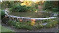
Pond behind dam in Kilvey Hill Community Woodland
The plaque on the right mentions "Friends International" and is dated 1974.
Image: © Nigel Davies
Taken: 7 Sep 2012
0.13 miles
2
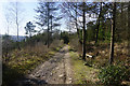
Path in Kilvey Wood
The path is on the lower slopes of Kilvey Hill. Views of the Tawe valley are beginning to open up far left.
Image: © Bill Boaden
Taken: 5 Apr 2016
0.17 miles
3
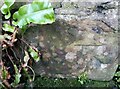
Ordnance Survey Cut Mark
This OS cut mark can be found on the rear wall of No56 Pentre-chwyth Road. It marks a point 41.297m above mean sea level.
Image: © Adrian Dust
Taken: 5 Jan 2021
0.19 miles
4
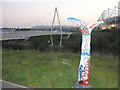
Mills type milepost near Swansea
Just opposite the Morfa Liberty stadium, this Mills type milepost is part of National Cycle Route 43. The bridge is part of the new stadium development and the Liberty stadium can be seen just to the right. The river being bridged is the Tawe and is navigable at this point.
Image: © Hywel Williams
Taken: 15 Oct 2006
0.19 miles
5
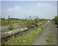
The remains of Upper Bank Station, Swansea
In this 1998 view, the decaying remains of Upper Bank Station can be seen. Upper Bank was opened in 1871 as part of the Swansea Vale Railway's route to Morriston. It eventually reached Brynamman. The whole line was taken over by the Midland Railway in 1876 and additional through routes were added as a result. Passenger services ceased in 1950 and complete closure took place in the 1960s.
By 1985 the only railway here was the section preserved by the SVR Society. In 2007, Swansea Council decided to redevelop the area and by 2010 the preserved railway was itself history, although the society itself lives on.
Image: © vectorkraft
Taken: 8 May 1998
0.19 miles
6
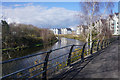
Cycle path by the River Tawe
Now lined by new apartment blocks. The cycle path is a more recent addition.
Image: © Bill Boaden
Taken: 5 Apr 2016
0.22 miles
7
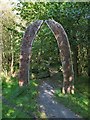
Archway Sculpture at Kilvey Community Woodland
This arch marks the start of the Sculpture Trail on Kilvey Hill. According to this page http://www.hardcorecarvers.co.uk/nansi/archway1.html the arch was created in 2001. I didn't see many other sculptures as I walked through the forest though.
The arch is by artist Nansi Hemming who has other work featured on Geograph too:
Image
Image
Image
Image: © Nigel Davies
Taken: 7 Sep 2012
0.24 miles