IMAGES TAKEN NEAR TO
FERRYSIDE, SA17 5UR
Introduction
This page details the photographs taken nearby to SA17 5UR by members of the Geograph project.
The Geograph project started in 2005 with the aim of publishing, organising and preserving representative images for every square kilometre of Great Britain, Ireland and the Isle of Man.

There are currently over 7.5m images from over14,400 individuals and you can help contribute to the project by visiting https://www.geograph.org.uk
Image Map (Loading...)


Getting Data...Please wait
Leaflet Map data © OpenStreetMap
Images are licensed for reuse under creativecommons.org/licenses/by-sa/2.0
Notes
- Clicking on the map will re-center to the selected point.
- The higher the marker number, the further away the image location is from the centre of the postcode.
Image Listing (63 Images Found)
Images are licensed for reuse under creativecommons.org/licenses/by-sa/2.0
Image
Details
Distance
1
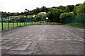
Inside Ferryside multi-use sports court
The court http://www.geograph.org.uk/photo/4559582 is 35 metres long, 17 metres wide.
Image: © Jaggery
Taken: 4 Jul 2015
0.05 miles
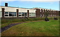
2
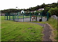
Multi-use sports court, Ferryside
At the edge of Ferryside Sports Ground, near the Carmarthen Road entrance.
Image: © Jaggery
Taken: 4 Jul 2015
0.07 miles
3
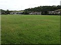
Ferryside Sports Ground
From the Carmarthen Road entrance.
Image: © Jaggery
Taken: 4 Jul 2015
0.08 miles
4

Ordnance Survey Cut Mark
This OS cut mark can be found on the gatepost of the cemetery. It marks a point 58.518m above mean sea level.
Image: © Adrian Dust
Taken: 16 Jul 2021
0.09 miles
5
Ferryside Village Forum Summer Market
Viewed from Carmarthen Road. The Summer Market starts today, Saturday July 4th 2015.
Image: © Jaggery
Taken: 4 Jul 2015
0.10 miles
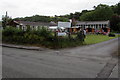
6
Former Ferryside Residential Education Centre
Viewed across Carmarthen Road in July 2015.
A local website describes this derelict building as a public liability and eyesore.
Image: © Jaggery
Taken: 4 Jul 2015
0.11 miles
7
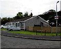
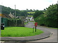
Maes-y-Ffynnon bungalows, Ferryside
Opposite Bethania chapel, http://www.geograph.org.uk/photo/4558802 out of shot on the left.
The No Cold Calling Area notice on the lamppost shows No Uninvited Sales People.
Image: © Jaggery
Taken: 4 Jul 2015
0.11 miles
8
Carmarthen Road bench, Ferryside
This bench was the perfect location for a first-time visitor to Ferryside to have a sandwich break.
The 20mph speed limit along Carmarthen Road increases to 30.
Image: © Jaggery
Taken: 4 Jul 2015
0.12 miles
9
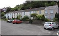
Wellfield Terrace houses, Ferryside
Row of six houses viewed from the corner of Water Street.
Image: © Jaggery
Taken: 4 Jul 2015
0.12 miles
10
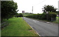
Houses on the edge of Ferryside
Looking south-east from Carmarthan Road along Glan Tywi.
Image: © Simon Mortimer
Taken: 10 Aug 2012
0.13 miles