IMAGES TAKEN NEAR TO
Ger Y Plas, KIDWELLY, SA17 5JX
Introduction
This page details the photographs taken nearby to Ger Y Plas, SA17 5JX by members of the Geograph project.
The Geograph project started in 2005 with the aim of publishing, organising and preserving representative images for every square kilometre of Great Britain, Ireland and the Isle of Man.

There are currently over 7.5m images from over14,400 individuals and you can help contribute to the project by visiting https://www.geograph.org.uk
Image Map (Loading...)


Getting Data...Please wait
Leaflet Map data © OpenStreetMap
Images are licensed for reuse under creativecommons.org/licenses/by-sa/2.0
Notes
- Clicking on the map will re-center to the selected point.
- The higher the marker number, the further away the image location is from the centre of the postcode.
Image Listing (18 Images Found)
Images are licensed for reuse under creativecommons.org/licenses/by-sa/2.0
Image
Details
Distance
1
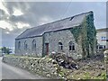
Derelict stone building
This old stone building, now showing signs of decay, looks as if it may once have been something more than just a farm building - a village hall, perhaps?
I have just learned that it was once a school, and that it became the centre for the village’s well-known brass/silver band. In 1896 the silver band won national competitions and was well respected in the community. The band continued until the early 1990s.
Image: © Alan Hughes
Taken: 19 Feb 2023
0.01 miles
2
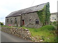
Derelict building in Llansaint
This was once the village school.
Image: © Eirian Evans
Taken: 24 May 2022
0.01 miles
3
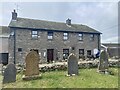
Kings Arms, Llansaint
Situated directly opposite the church, the village pub is said to be 200 years old.
Image: © Alan Hughes
Taken: 19 Feb 2023
0.02 miles
4
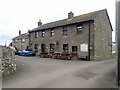
The Kings Arms, Llansaint
Opposite the church at the centre of the village
Image: © Eirian Evans
Taken: 24 May 2022
0.02 miles
5
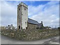
All Saints Church, Llansaint
Until the 17th century Llansaint was known as Halkenchurche meaning church of the saints.
https://en.wikipedia.org/wiki/Llansaint.
Image: © Alan Hughes
Taken: 19 Feb 2023
0.03 miles
6
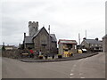
All Saints Church, Llansaint
In a walled churchyard in the centre of the village.
Image: © Eirian Evans
Taken: 24 May 2022
0.03 miles
7
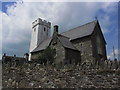
All Saint's Church, Llansaint near Ferryside
Image: © Colin Park
Taken: 14 Jul 2013
0.03 miles
8
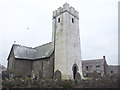
All Saint's Church, Llansaint
Eglwys yr holl saint, Llansaint - This medieval church has a landmark tower, and is Grade B listed.
Image: © Robin Lucas
Taken: 16 Nov 2013
0.03 miles
9
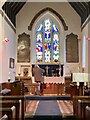
Altar window
All Saints Church, Llansaint.
Image: © Alan Hughes
Taken: 19 Feb 2023
0.04 miles