IMAGES TAKEN NEAR TO
Pontantwn, KIDWELLY, SA17 5HP
Introduction
This page details the photographs taken nearby to SA17 5HP by members of the Geograph project.
The Geograph project started in 2005 with the aim of publishing, organising and preserving representative images for every square kilometre of Great Britain, Ireland and the Isle of Man.

There are currently over 7.5m images from over14,400 individuals and you can help contribute to the project by visiting https://www.geograph.org.uk
Image Map
Images are licensed for reuse under creativecommons.org/licenses/by-sa/2.0
Notes
- Clicking on the map will re-center to the selected point.
- The higher the marker number, the further away the image location is from the centre of the postcode.
Image Listing (23 Images Found)
Images are licensed for reuse under creativecommons.org/licenses/by-sa/2.0
Image
Details
Distance
1
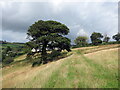
Hen gât fochyn / An old kissing gate
Llwybr troed cyhoeddus yn cyrraedd pentre Pontantwn. Yn anffodus, wrth ysgrifennu hwn mae'r llwybr wedi ei rwystro.
A public footpath approaches the village of Pontantwn (trans. Anton's bridge). Unfortunately, at the time of writing the path is obstructed.
Image: © Alan Richards
Taken: 31 Jul 2023
0.04 miles
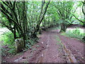
2
Llwybr i Bontantwn / Path to Pontantwn
Llwybr troed cyhoeddus yn agosau at bentre Pontantwn.
A public footpath approaches the village of Pontantwn (trans. Anton's bridge).
Image: © Alan Richards
Taken: 31 Jul 2023
0.07 miles
3
Rhyd Nant Drysgeirch / Nant Drysgeirch ford
Llwybr troed cyhoeddus yn rhydio Nant Drysgeirch. Yn anffodus, wrth ysgrifennu hwn mae'r llwybr wedi ei rwystro.
A public footpath fords Nant Drysgeirch. Unfortunately, at the time of writing the path is obstructed.
Image: © Alan Richards
Taken: 31 Jul 2023
0.10 miles
6
Llwybr ger Ponantwn / Path near Ponantwn
Hen bostyn gât o garreg ar lwybr troed cyhoeddus ger Pontantwn. Yn anffodus, wrth ysgrifennu hwn mae'r llwybr wedi ei rwystro.
An old abandoned stone gate post on a public footpath near Pontantwn (trans. Anton's bridge). Unfortunately, at the time of writing the path is obstructed.
Image: © Alan Richards
Taken: 31 Jul 2023
0.15 miles
7
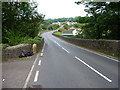
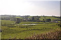
Pont Antwn
A view along the B4309, across the Grade II listed Pont Antwn https://www.britishlistedbuildings.co.uk/300082287-pont-antwn-llangyndeyrn#.WUbxWdQrLGg, which is a 19th century widening of an 18th century bridge - the original remains in place below, but is hard to photograph.
Image: © Richard Law
Taken: 1 Jun 2017
0.16 miles
8
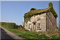
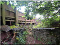
Derelict cottage - Pontantwyn
A sign on the wall warns that 'Trespassers will be Prosecuted' - made no difference to the Swallows flitting in and out!
Image: © Mick Lobb
Taken: 18 Apr 2009
0.16 miles
9
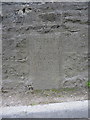
Dedication stone on the bridge at Pontantwn
As far as I can make out, it records that "This bridge was erected at the expence (ie expense) of the County by Thos Richard Mafon (ie Mason) Llandeilog 1783" - which is close to the date and builder mentioned in the Grade II listing details https://www.britishlistedbuildings.co.uk/300082287-pont-antwn-llangyndeyrn#.WUbOf9QrLGg which record the date of 1785 and a name of Thomas Richards. The original bridge lies below the modern one, and is quite hard to photograph without trespassing into fields to the west
Image: © Richard Law
Taken: 1 Jun 2017
0.17 miles
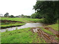
10
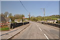
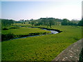
The B4309 crossing the Gwendraeth Fach at Pontantwn
Image: © Mick Lobb
Taken: 18 Apr 2009
0.17 miles