IMAGES TAKEN NEAR TO
Crwbin, KIDWELLY, SA17 5DB
Introduction
This page details the photographs taken nearby to SA17 5DB by members of the Geograph project.
The Geograph project started in 2005 with the aim of publishing, organising and preserving representative images for every square kilometre of Great Britain, Ireland and the Isle of Man.

There are currently over 7.5m images from over14,400 individuals and you can help contribute to the project by visiting https://www.geograph.org.uk
Image Map
Images are licensed for reuse under creativecommons.org/licenses/by-sa/2.0
Notes
- Clicking on the map will re-center to the selected point.
- The higher the marker number, the further away the image location is from the centre of the postcode.
Image Listing (5 Images Found)
Images are licensed for reuse under creativecommons.org/licenses/by-sa/2.0
Image
Details
Distance
1
![In search of Bwrdd Arthur [2]](https://s2.geograph.org.uk/geophotos/04/15/76/4157614_b3720ac1_120x120.jpg)
In search of Bwrdd Arthur [2]
If one was expecting to find some monumental prehistoric cromlech in the style of Pentre Ifan [SN0937], then one would be disappointed as Bwrdd Arthur turns out to be the ruined cromlech represented by the pile of boulders at the bottom left of this picture.
Image: © Gordon Hatton
Taken: 1 Sep 2014
0.12 miles
2
![In search of Bwrdd Arthur [1]](https://s0.geograph.org.uk/geophotos/04/15/75/4157572_714ec8ed_120x120.jpg)
In search of Bwrdd Arthur [1]
The OS map shows a burial chamber with the name of Bwrdd Arthur on this hilltop. Is this it? Apparently not, but it isn't far away. A pleasant view eastwards towards the bigger hills of the Carmarthen Van.
Image: © Gordon Hatton
Taken: 1 Sep 2014
0.19 miles
3
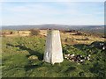
Trig pillar on Mynydd Llangyndeyrn
A short walk from the road to the south rewards you with a fantastic view which explains why this pillar is here.
You can see out to the Carmarthen bay, Caldey Island, the Preselli Mountains, Frenni Fawr, Bannau Sir Gar and Mynydd Sylen.
Image: © Nigel Davies
Taken: 4 Feb 2007
0.25 miles
4
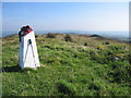
Mynydd Llangyndeyrn
Super little summit with easy access from parking at top of farm road.
Name: Mynydd Llangyndeyrn
Hill number: 2285
Height: 263m / 863ft
Area: 32B: Carmarthen to Vale of Neath
Class: Ma
Grid ref: SN 48239 13275
Summit feature: rock 3m SSE of trig point
Drop: 170m
Col: 93m SN523137
Image: © Rude Health
Taken: 20 Sep 2008
0.25 miles
5
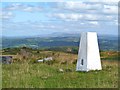
OS trig point on Mynydd Llangynderyn
A modest 262m above sea level, but a hilltop with a splendid 360 degree view. This shot looks slightly north of east towards the higher tops of the Black Mountain/Carmarthen Van.
Image: © Gordon Hatton
Taken: 1 Sep 2014
0.25 miles