IMAGES TAKEN NEAR TO
Crwbin, KIDWELLY, SA17 5BS
Introduction
This page details the photographs taken nearby to SA17 5BS by members of the Geograph project.
The Geograph project started in 2005 with the aim of publishing, organising and preserving representative images for every square kilometre of Great Britain, Ireland and the Isle of Man.

There are currently over 7.5m images from over14,400 individuals and you can help contribute to the project by visiting https://www.geograph.org.uk
Image Map
Images are licensed for reuse under creativecommons.org/licenses/by-sa/2.0
Notes
- Clicking on the map will re-center to the selected point.
- The higher the marker number, the further away the image location is from the centre of the postcode.
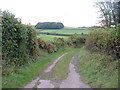
Image Listing (3 Images Found)
Images are licensed for reuse under creativecommons.org/licenses/by-sa/2.0
Image
Details
Distance
1
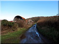
Ffarm Capel Dyddgen Farm
Yn agosau at Ffarm Capel Dyddgen a enwyd ar ol yr eglwys gerllaw sy bellach yn adfail.
Approaching Capel Dyddgen Farm named after the nearby ruined church.
Image: © Alan Richards
Taken: 30 Jan 2016
0.20 miles
3
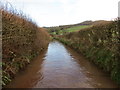
Heol dan ddwr / Road under water
Heol ddiwyneb dan ddwr ar ol glaw trwm.
An unsurfaced road under water after heavy rain.
Image: © Alan Richards
Taken: 30 Jan 2016
0.24 miles