IMAGES TAKEN NEAR TO
Bridge Street, KIDWELLY, SA17 4UU
Introduction
This page details the photographs taken nearby to Bridge Street, SA17 4UU by members of the Geograph project.
The Geograph project started in 2005 with the aim of publishing, organising and preserving representative images for every square kilometre of Great Britain, Ireland and the Isle of Man.

There are currently over 7.5m images from over14,400 individuals and you can help contribute to the project by visiting https://www.geograph.org.uk
Image Map (Loading...)


Getting Data...Please wait
Leaflet Map data © OpenStreetMap
Images are licensed for reuse under creativecommons.org/licenses/by-sa/2.0
Notes
- Clicking on the map will re-center to the selected point.
- The higher the marker number, the further away the image location is from the centre of the postcode.
Image Listing (267 Images Found)
Images are licensed for reuse under creativecommons.org/licenses/by-sa/2.0
Image
Details
Distance
1
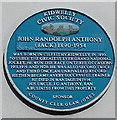
John Randolph Anthony blue plaque, Kidwelly
The Kidwelly Civic Society plaque is on the wall here. http://www.geograph.org.uk/photo/3769879
Image: © Jaggery
Taken: 29 Mar 2013
0.01 miles
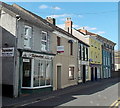
2
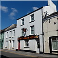
Best Kebab and Pizza, Kidwelly
Takeaway in Bridge Street.
Image: © Jaggery
Taken: 29 Mar 2013
0.01 miles
3
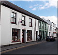
Mr Joseph, Kidwelly
Curtains and upholstery shop in Bridge Street. There is a blue plaque http://www.geograph.org.uk/photo/3769881 on the doorway.
Image: © Jaggery
Taken: 29 Mar 2013
0.01 miles
4
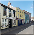
Castle News, Kidwelly
Newsagents in Bridge Street also selling stationery, gifts, cards, toys etc.
Image: © Jaggery
Taken: 29 Mar 2013
0.01 miles
5
The Tajmahal, Kidwelly
Indian takeaway at 10 Bridge Street. Most references show the name as Taj Mahal,
the business's own website has Taj-Mahal whereas it's Tajmahal in this view...
Image: © Jaggery
Taken: 29 Mar 2013
0.02 miles
6
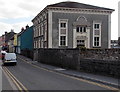
Capel Sul, Kidwelly
Bridge Street chapel on the south bank of the Gwendraeth Fach river.
Built in 1862 as Rumsey House, converted to a chapel in the 1920s.
Image: © Jaggery
Taken: 29 Mar 2013
0.02 miles
7
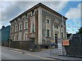
Capel Sul, Kidwelly
Italianate style building, at one point a chapel, now a community building.
Image: © Oscar Taylor
Taken: 17 Jul 2024
0.02 miles
8
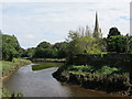
Afon Gwendraeth Fach River
Afon Gwendraeth Fach, Cydweli gyda thwr yr eglwys yn y pellter.
The Gwendraeth Fach River (trans. lesser white sands), Kidwelly < Cydweli (land of Cadwel) with the church steeple in the distance.
Image: © Alan Richards
Taken: 19 Aug 2012
0.02 miles
9
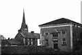
Church and chapel, Kidwelly, Carmarthenshire
Image: © nick macneill
Taken: 6 Apr 1995
0.02 miles
10
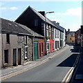
Bridge Street Kidwelly
Looking SSE from the edge of the bridge over the Gwendraeth Fach river.
Image: © Jaggery
Taken: 29 Mar 2013
0.03 miles