IMAGES TAKEN NEAR TO
Elfed Road, SWANSEA, SA1 6ST
Introduction
This page details the photographs taken nearby to Elfed Road, SA1 6ST by members of the Geograph project.
The Geograph project started in 2005 with the aim of publishing, organising and preserving representative images for every square kilometre of Great Britain, Ireland and the Isle of Man.

There are currently over 7.5m images from over14,400 individuals and you can help contribute to the project by visiting https://www.geograph.org.uk
Image Map
Images are licensed for reuse under creativecommons.org/licenses/by-sa/2.0
Notes
- Clicking on the map will re-center to the selected point.
- The higher the marker number, the further away the image location is from the centre of the postcode.
Image Listing (45 Images Found)
Images are licensed for reuse under creativecommons.org/licenses/by-sa/2.0
Image
Details
Distance
1
NEW
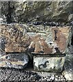
Benchmark 1 Islwyn Road Townhill
An Ordnance Cut Mark can be found on the boundary wall of 1 Islwyn Road, Townhill, Swansea. It marks a height of 141.327m above mean sea level.
Image: © John Jenkins
Taken: 12 Mar 2025
0.05 miles
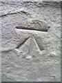
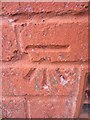
2
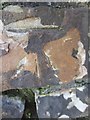
Ordnance Survey Cut Mark
This OS cut mark can be found on the wall at the junction of Islwyn Road & Llewelyn Circle. It marks a point 141.327m above mean sea level.
Image: © Adrian Dust
Taken: 22 Nov 2013
0.05 miles
3
Ordnance Survey Rivet
This OS rivet can be found on the steps to the NE of Pen-Y-Graig Road. It marks a point 128.696m above mean sea level.
Image: © Adrian Dust
Taken: 20 Nov 2013
0.06 miles
4
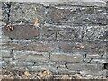
Ordnance Survey Cut Mark
This OS cut mark can be found on the wall below No1 Dyfed Avenue. It marks a point 137.995m above mean sea level.
Image: © Adrian Dust
Taken: 15 Jul 2024
0.09 miles
5
Ordnance Survey Cut Mark
This OS cut mark can be found on the rear wall of No3 Fairfield Terrace which is on Pen-Y-Graig Road. It marks a point 110.274m above mean sea level.
Image: © Adrian Dust
Taken: 31 Oct 2013
0.14 miles
6
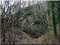
Rock face in Rosehill Quarry
The port of Swansea is backed by a huge mound of sandstone over which the districts of Townhill, Mount Pleasant and Uplands now sprawl. This rock face reveals the blue Pennant stone that provided building material for housing during the second half of the C19 when this was a working stone quarry.
Image: © Natasha Ceridwen de Chroustchoff
Taken: 21 Oct 2009
0.15 miles
7
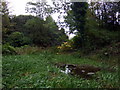
Pool in Rosehill quarry
This little pocket wilderness on the site of a former quarry supports over 100 plant species and 30 different birds and a variety of amphibians in its trees, rocky sides and fresh running water.
Sandstone was quarried here in the mid-C19 for building the surrounding residential street. After a period of neglect it was rescued and turned into a recreational and natural history resource for the local community. On the day I visited a group of tiny children, all dressed in red like a troop of pixies, were playing hide and seek under the watching eye of their teachers.
Image: © Natasha Ceridwen de Chroustchoff
Taken: 21 Oct 2009
0.15 miles
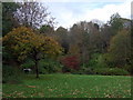
8

Rosehill Quarry Community Park
This site was once a quarry. Now it is a park and small nature reserve hidden away right in the middle of dense housing.
The information board tells of how this flattened area was also previously a tennis club.
Image: © Nigel Davies
Taken: 24 Sep 2007
0.16 miles
9
Rosehill Quarry recreation area
This part of the community park once held a popular tennis club. The flat area that remains is now used for group activities and for introducing ethnic minority groups to outdoor recreation; it also has some open-air exercise equipment.
Image: © Natasha Ceridwen de Chroustchoff
Taken: 21 Oct 2009
0.16 miles
10
Ordnance Survey Cut Mark
This OS cut mark can be found on No58 Islwyn Road. It marks a point 141.110m above mean sea level.
Image: © Adrian Dust
Taken: 20 Nov 2013
0.17 miles