IMAGES TAKEN NEAR TO
Sunnymead Close, SWANSEA, SA1 6SD
Introduction
This page details the photographs taken nearby to Sunnymead Close, SA1 6SD by members of the Geograph project.
The Geograph project started in 2005 with the aim of publishing, organising and preserving representative images for every square kilometre of Great Britain, Ireland and the Isle of Man.

There are currently over 7.5m images from over14,400 individuals and you can help contribute to the project by visiting https://www.geograph.org.uk
Image Map (Loading...)


Getting Data...Please wait
Leaflet Map data © OpenStreetMap
Images are licensed for reuse under creativecommons.org/licenses/by-sa/2.0
Notes
- Clicking on the map will re-center to the selected point.
- The higher the marker number, the further away the image location is from the centre of the postcode.
Image Listing (10 Images Found)
Images are licensed for reuse under creativecommons.org/licenses/by-sa/2.0
Image
Details
Distance
1
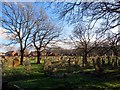
Mynwent Eglwys San Pedr / St Peter's Churchyard
Mynwent Eglwys San Pedr yng Nghoced.
St Peter's Churchyard, Cockett.
Image: © Alan Richards
Taken: 16 Jan 2015
0.09 miles
2
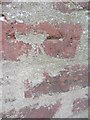
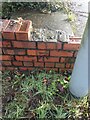
Ordnance Survey Cut Mark
This damaged OS cut mark can be found on the wall of No381 Gors Avenue. It marks a point 103.403m above mean sea level.
Image: © Adrian Dust
Taken: 12 Mar 2014
0.10 miles
3
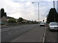
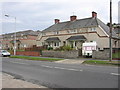
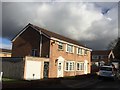
Gors Avenue, Townhill
The prominent speed camera suggests that this straight road is tempting drivers to break the speed limit.
Image: © HelenK
Taken: 29 Sep 2007
0.10 miles
4
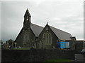
St Peter's Church
The Ordnance Survey used the Belfry as a 3rd Order Intersected Station (SN80/INT019).
Image: © Adrian Dust
Taken: 7 Apr 2011
0.14 miles
5
Aestivating housebling
Awaiting the festive season.
Image: © HelenK
Taken: 29 Sep 2007
0.16 miles
6
Ordnance Survey Cut Mark
This OS cut mark can be found at the junction of St Peter's Terrace & Cockett Road. It marks a point 100.023m above mean sea level.
Image: © Adrian Dust
Taken: 12 Mar 2014
0.19 miles
7
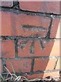
Benchmark. Cut mark, North junction of Cockett Road and Saint Peters Terrace
Cut mark can be found at the junction of Cockett Road and Saint Peters Terrace on a red bricked wall surrounding steps.
Image: © John Jenkins
Taken: 21 Feb 2023
0.19 miles
8
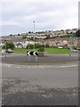
Roundabout on Gors Avenue
Facing SE. The church or chapel marked as being at the NW of this roundabout on the map has recently been demolished.
Image: © HelenK
Taken: 29 Sep 2007
0.21 miles
10
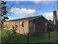
Church of Jesus Christ of Latter-Day Saints
Church of Jesus Christ of Latter Day Saints, Cockett Road, Swansea.
Image: © Alan Hughes
Taken: 5 Nov 2017
0.23 miles