IMAGES TAKEN NEAR TO
Fairfield Terrace, SWANSEA, SA1 6JX
Introduction
This page details the photographs taken nearby to Fairfield Terrace, SA1 6JX by members of the Geograph project.
The Geograph project started in 2005 with the aim of publishing, organising and preserving representative images for every square kilometre of Great Britain, Ireland and the Isle of Man.

There are currently over 7.5m images from over14,400 individuals and you can help contribute to the project by visiting https://www.geograph.org.uk
Image Map
Images are licensed for reuse under creativecommons.org/licenses/by-sa/2.0
Notes
- Clicking on the map will re-center to the selected point.
- The higher the marker number, the further away the image location is from the centre of the postcode.
Image Listing (74 Images Found)
Images are licensed for reuse under creativecommons.org/licenses/by-sa/2.0
Image
Details
Distance
1
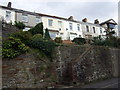
Houses in Terrace Road
On a higher level than the street, these modernised Victorian houses have steps leading up to elevated gardens along a retaining wall.
Image: © Natasha Ceridwen de Chroustchoff
Taken: 21 Oct 2009
0.04 miles
2
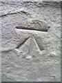
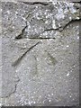
Ordnance Survey Cut Mark
This OS cut mark can be found on the rear wall of No3 Fairfield Terrace which is on Pen-Y-Graig Road. It marks a point 110.274m above mean sea level.
Image: © Adrian Dust
Taken: 31 Oct 2013
0.04 miles
4
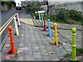
Colourful bollards
Where Constitution Hill meets Terrace Road - is it to enhance their visibility or something to do with the nearby primary school?
Image: © Natasha Ceridwen de Chroustchoff
Taken: 21 Oct 2009
0.05 miles
5
Ordnance Survey Cut Mark
This OS cut mark can be found at the junction of Constitution Hill and Terrace Road. It marks a point 82.778m above mean sea level.
Image: © Adrian Dust
Taken: 31 Oct 2013
0.05 miles
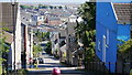
6
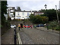
Constitution Hill meets Terrace Road
Constitution Hill reaches its highest point here but this is not yet the top of Townhill.
The white house must have a stunning view straight down this notoriously steep street.
Image: © Natasha Ceridwen de Chroustchoff
Taken: 21 Oct 2009
0.06 miles
7
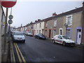
Western Street, Swansea
In the Sandfields area of Swansea.
Image: © Deborah Tilley
Taken: 21 Feb 2011
0.06 miles
8

Penmaen Terrace
The corner with Constitution Hill, showing the hill's re-laid/renewed 'cobbles' as they are termed, although strictly speaking they are 'setts', i.e. dressed stone blocks.
NB The number of chimney pots indicate these houses would once have had a fireplace in every room!
Image: © Natasha Ceridwen de Chroustchoff
Taken: 21 Oct 2009
0.07 miles
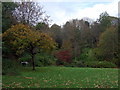
9

Rosehill Quarry Community Park
This site was once a quarry. Now it is a park and small nature reserve hidden away right in the middle of dense housing.
The information board tells of how this flattened area was also previously a tennis club.
Image: © Nigel Davies
Taken: 24 Sep 2007
0.07 miles
10
Rosehill Quarry recreation area
This part of the community park once held a popular tennis club. The flat area that remains is now used for group activities and for introducing ethnic minority groups to outdoor recreation; it also has some open-air exercise equipment.
Image: © Natasha Ceridwen de Chroustchoff
Taken: 21 Oct 2009
0.07 miles