1
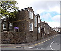
Former Swansea Workhouse administrative block
Viewed across Terrace Road. Originally part of Swansea Workhouse, which was later known as Tawe Lodge, and then Mount Pleasant Hospital. After the hospital's closure in 1995, the site was used for student accommodation. In 2000 the site was redeveloped. Some of the old buildings were preserved and converted to residential use, as here.
Image: © Jaggery
Taken: 27 Apr 2014
0.03 miles
2
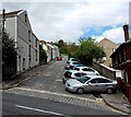
Harries Street, Swansea
Viewed across Terrace Road. The roadway extends for 100 metres ahead, to steps up to Hewson Street. The cars are parked at a perimeter wall of The Mountain Dew Inn. http://www.geograph.org.uk/photo/3953480
Image: © Jaggery
Taken: 27 Apr 2014
0.04 miles
3
The Mountain Dew Inn, Swansea
Located at 10-12 Terrace Road, on the corner of Harries Street.
Image: © Jaggery
Taken: 27 Apr 2014
0.05 miles
4
Cosy Cafe, Swansea
In late April 2014 there was a Freehold For Sale board on the wall
of Cosy Cafe, 73 Mount Pleasant, on the corner of Stanley Place (on the right).
Image: © Jaggery
Taken: 27 Apr 2014
0.05 miles
5
The Old Hospital, Mount Pleasant, Swansea
Viewed from Terrace Road. Originally Swansea Workhouse, later known as Tawe Lodge, and then Mount Pleasant Hospital. After the hospital's closure in 1995, the site was used for student accommodation.
In 2000 the site was redeveloped. Some of the old buildings were preserved and converted to residential use.
Image: © Jaggery
Taken: 27 Apr 2014
0.06 miles
6
Ordnance Survey Cut Mark
This OS cut mark can be found on the wall to the SW of Bryn-Syfi Terrace at the junction. It marks a point 67.303m above mean sea level.
Image: © Adrian Dust
Taken: 23 Oct 2013
0.06 miles
7
University Faculty building, Swansea
The Faculty of Applied Design and Engineering building is part of the University of Wales Trinity Saint David, Swansea campus, viewed from the corner of Terrace Road and Stanley Place.
Image: © Jaggery
Taken: 27 Apr 2014
0.06 miles
8
East along Norfolk Street, Swansea
From Harcourt Street looking towards Stanley Place. Norfolk Bakery http://www.geograph.org.uk/photo/4002763 is on the left.
Image: © Jaggery
Taken: 27 Apr 2014
0.09 miles
9
Ordnance Survey Cut Mark
This OS cut mark can be found on the west face of the house which was once a post office. It marks a point 78.062m above mean sea level.
Image: © Adrian Dust
Taken: 22 Nov 2013
0.09 miles
10
Jodie Locks, Swansea
Unisex hair salon at 51 Terrace Road, on the corner of Harcourt Street.
Image: © Jaggery
Taken: 27 Apr 2014
0.09 miles


