IMAGES TAKEN NEAR TO
Golwg Yr Allt, SWANSEA, SA1 6AN
Introduction
This page details the photographs taken nearby to Golwg Yr Allt, SA1 6AN by members of the Geograph project.
The Geograph project started in 2005 with the aim of publishing, organising and preserving representative images for every square kilometre of Great Britain, Ireland and the Isle of Man.

There are currently over 7.5m images from over14,400 individuals and you can help contribute to the project by visiting https://www.geograph.org.uk
Image Map (Loading...)


Getting Data...Please wait
Leaflet Map data © OpenStreetMap
Images are licensed for reuse under creativecommons.org/licenses/by-sa/2.0
Notes
- Clicking on the map will re-center to the selected point.
- The higher the marker number, the further away the image location is from the centre of the postcode.
Image Listing (8 Images Found)
Images are licensed for reuse under creativecommons.org/licenses/by-sa/2.0
Image
Details
Distance
1
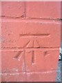
Ordnance Survey Cut Mark
This OS cut mark can be found on No32 Heol-Y-Gors. It marks a point 99.420m above mean sea level.
Image: © Adrian Dust
Taken: 12 Mar 2014
0.13 miles
2
Ordnance Survey Cut Mark
This OS cut mark can be found on the wall of No61 Gwent Road. It marks a point 106.973m above mean sea level.
Image: © Adrian Dust
Taken: 12 Mar 2014
0.16 miles
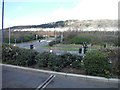
3
Pont Lein. Railway Bridge.
Sylwer ar y bont droed gaedig ar y chwith o'r llun.
The footbridge on the left is encased in mesh.
Image: © Gerallt Pennant
Taken: 18 Apr 2007
0.18 miles
4
Aldi supermarket in Swansea
On the corner of Carmarthen Road and Heol y Cwmdu.
Image: © Jaggery
Taken: 25 Sep 2013
0.20 miles
5
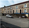
Cave Street Swansea
Viewed from the Carmarthen Road end. Not a survivor from Swansea's Fred Flintstone era, Cave Street was probably named after a person named Cave. There is a Cave Street in several other places in the UK, including Bristol, Hull and Oxford.
Image: © Jaggery
Taken: 25 Sep 2013
0.22 miles
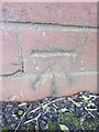
6
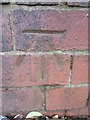
Ordnance Survey Cut Mark
This OS cut mark can be found on the wall of No23 Gwent Road. It marks a point 115.449m above mean sea level.
Image: © Adrian Dust
Taken: 30 Dec 2013
0.23 miles
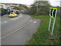
7
Swansea : Carmarthen Road A483
A road heading through Swansea as seen from the McDonald's.
Image: © Lewis Clarke
Taken: 23 Mar 2014
0.23 miles
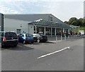
8
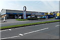
Kwit-Fit and Topps Tiles, Swansea
Two businesses alongside the A483 Carmarthen Road in the Cwmdu area of Swansea.
Image: © Jaggery
Taken: 25 Sep 2013
0.24 miles