IMAGES TAKEN NEAR TO
Riverside, BURRY PORT, SA16 0RB
Introduction
This page details the photographs taken nearby to Riverside, SA16 0RB by members of the Geograph project.
The Geograph project started in 2005 with the aim of publishing, organising and preserving representative images for every square kilometre of Great Britain, Ireland and the Isle of Man.

There are currently over 7.5m images from over14,400 individuals and you can help contribute to the project by visiting https://www.geograph.org.uk
Image Map
Images are licensed for reuse under creativecommons.org/licenses/by-sa/2.0
Notes
- Clicking on the map will re-center to the selected point.
- The higher the marker number, the further away the image location is from the centre of the postcode.
Image Listing (79 Images Found)
Images are licensed for reuse under creativecommons.org/licenses/by-sa/2.0
Image
Details
Distance
1
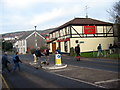
Pemberton Arms
Cerddwyr yn croesi'r A484 wrth Dafarn y Pemperton Arms.
Walkers crossing the A484 next to the Pemberton Arms.
Image: © Alan Richards
Taken: 5 Feb 2006
0.01 miles
2
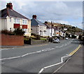
Down Colby Road, Burry Port
The A484 Colby Road descends towards the Pemberton Arms https://www.geograph.org.uk/photo/5705764 in the background
Image: © Jaggery
Taken: 16 Mar 2018
0.02 miles
3
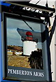
Pemberton Arms name sign, Burry Port
Depicting Burry Port Lighthouse https://www.geograph.org.uk/photo/3383027 the sign is on the left here. https://www.geograph.org.uk/photo/5705764
Image: © Jaggery
Taken: 13 Mar 2018
0.03 miles
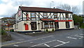
4
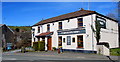
Pemberton Arms, Burry Port
Pub viewed across the A484 Colby Road in March 2018. https://www.geograph.org.uk/photo/5705772 to the name sign on the left.
Here's https://www.geograph.org.uk/photo/3608839 how the pub looked in April 2012.
Image: © Jaggery
Taken: 13 Mar 2018
0.03 miles
5
Cwm Capel this way, Burry Port
The sign on the north side of the A484 Colby Road points toward a path to Cwm Capel, Welsh for Chapel Valley.
Image: © Jaggery
Taken: 13 Mar 2018
0.03 miles
6
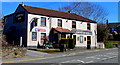
Pemberton Arms, Colby Road, Burry Port
Viewed in March 2018. Here's https://www.geograph.org.uk/photo/3608839 how the pub looked in April 2012.
Image: © Jaggery
Taken: 13 Mar 2018
0.03 miles
7
Pemberton Arms, Burry Port
Pub viewed across the A484 Colby Road.
Image: © Jaggery
Taken: 15 Apr 2012
0.03 miles
8
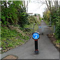
Old tramway now a cycle way, Burry Port
Looking south from Colby Road along a cyclepath and footpath on the route of a former tramway.
Image: © Jaggery
Taken: 15 Apr 2012
0.03 miles
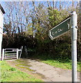
9
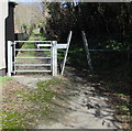
Inwardly-sloping barrier and a gate across a path towards Cwm Capel, Carmarthenshire
Viewed from the north side of the A484 Colby Road. The path ahead https://www.geograph.org.uk/photo/5793453 leads to Cwm Capel.
Image: © Jaggery
Taken: 13 Mar 2018
0.03 miles
10
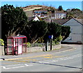
Colby Road bus stop and shelter, Burry Port
On the north side of the A484 Colby Road. A speed camera is nearby.
Image: © Jaggery
Taken: 13 Mar 2018
0.04 miles