IMAGES TAKEN NEAR TO
Graig, BURRY PORT, SA16 0DT
Introduction
This page details the photographs taken nearby to SA16 0DT by members of the Geograph project.
The Geograph project started in 2005 with the aim of publishing, organising and preserving representative images for every square kilometre of Great Britain, Ireland and the Isle of Man.

There are currently over 7.5m images from over14,400 individuals and you can help contribute to the project by visiting https://www.geograph.org.uk
Image Map (6 Images)


Getting Data...Please wait
Leaflet Map data © OpenStreetMap
Images are licensed for reuse under creativecommons.org/licenses/by-sa/2.0
Notes
- Clicking on the map will re-center to the selected point.
- The higher the marker number, the further away the image location is from the centre of the postcode.
Image Listing (6 Images Found)
Images are licensed for reuse under creativecommons.org/licenses/by-sa/2.0
Image
Details
Distance
1

Lane and track, Graig, Burry Port
The lane leads to Cwm Capel and a chapel, the track to a trash grid on Nant Dyfatty.
Image: © Humphrey Bolton
Taken: 22 Apr 2019
0.08 miles
2
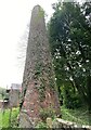
Ivy covered chimney
Ventilation chimney at Cwm Capel colliery.
Image: © Alan Hughes
Taken: 20 Aug 2021
0.12 miles
3

Nant Dyfatty and the track to the trash grid
Image: © Humphrey Bolton
Taken: 22 Apr 2019
0.22 miles
4

Driveways off the lane at Cwm Capel, Burry Port
Image: © Humphrey Bolton
Taken: 22 Apr 2019
0.23 miles
5
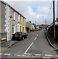
Erw Terrace, Burry Port
Looking to the ENE along Erw Terrace from Y Graig.
The bilingual sign on the left shows that Erw Terrace is Teras yr Erw in Welsh.
Image: © Jaggery
Taken: 16 Mar 2018
0.23 miles
6

Trash grid on Nant Dyfatty, Burry Port
Image: © Humphrey Bolton
Taken: 22 Apr 2019
0.23 miles