IMAGES TAKEN NEAR TO
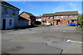
Heol Gwendraeth, BURRY PORT, SA16 0AN
Introduction
This page details the photographs taken nearby to Heol Gwendraeth, SA16 0AN by members of the Geograph project.
The Geograph project started in 2005 with the aim of publishing, organising and preserving representative images for every square kilometre of Great Britain, Ireland and the Isle of Man.

There are currently over 7.5m images from over14,400 individuals and you can help contribute to the project by visiting https://www.geograph.org.uk
Image Map
Images are licensed for reuse under creativecommons.org/licenses/by-sa/2.0
Notes
- Clicking on the map will re-center to the selected point.
- The higher the marker number, the further away the image location is from the centre of the postcode.
Image Listing (84 Images Found)
Images are licensed for reuse under creativecommons.org/licenses/by-sa/2.0
Image
Details
Distance
1

Llys-y-Llyfrgell, Burry Port
Cul-de-sac beyond the western end of Carway Street.
Llys-y-Llyfrgell is Welsh for Library Court.
Burry Port Library https://www.geograph.org.uk/photo/5706752 is nearby.
Image: © Jaggery
Taken: 13 Mar 2018
0.04 miles
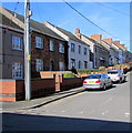
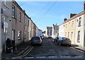
2
Houses near Burry Port Library
The houses are set back 35 metres from the western end of Carway Street. The library is on the left. https://www.geograph.org.uk/photo/5706752
Image: © Jaggery
Taken: 13 Mar 2018
0.06 miles
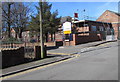
3
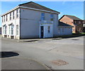
Burry Port Library, Carway Street, Burry Port
Part of Carmarthenshire County Council's library service, located at the western end of Carway Street.
Image: © Jaggery
Taken: 13 Mar 2018
0.06 miles
4
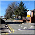
West along Heol Elfed, Burry Port
This part of Heol Elfed is past the southern edge of Glan-y-Môr School (Ysgol Glan-y-Môr in Welsh).
Image: © Jaggery
Taken: 13 Mar 2018
0.06 miles
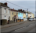
5
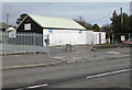
Harbour Tyres, Seaview Terrace, Burry Port
At the western end of Seaview Terrace, viewed across the B4311 Ashburnham Road.
Image: © Jaggery
Taken: 8 Mar 2018
0.08 miles
6
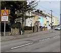
Rhesi unigol o draffig/Single file traffic sign, Ashburnham Road, Burry Port
The Welsh/English sign is alongside the B4311 Ashburnham Road at the edge of Seaview Terrace.
Image: © Jaggery
Taken: 8 Mar 2018
0.09 miles
7
West side of Pemberton Avenue, Burry Port
Viewed from Carway Street looking along Pemberton Avenue towards Heol Elfed.
Image: © Jaggery
Taken: 13 Mar 2018
0.09 miles
8
Southeast corner of Ysgol Glan-y-M?r, Burry Port
On the corner of Pemberton Avenue and Heol Elfed. Ysgol Glan-y-Môr (Glan-y-Môr School in English) is a comprehensive school for children aged 11-16.
Image: © Jaggery
Taken: 13 Mar 2018
0.09 miles
9
Western end of Seaview Terrace, Burry Port
Viewed across the B4311 Ashburnham Road.
Image: © Jaggery
Taken: 8 Mar 2018
0.10 miles
10
West along Carway Street from Elkington Road, Burry Port
The Welsh/English sign on the left points the way to Ysgol Glan-y-Mor/Glan-y-Mor School.
Image: © Jaggery
Taken: 13 Mar 2018
0.11 miles