IMAGES TAKEN NEAR TO
Orchard Street, SWANSEA, SA1 5BB
Introduction
This page details the photographs taken nearby to Orchard Street, SA1 5BB by members of the Geograph project.
The Geograph project started in 2005 with the aim of publishing, organising and preserving representative images for every square kilometre of Great Britain, Ireland and the Isle of Man.

There are currently over 7.5m images from over14,400 individuals and you can help contribute to the project by visiting https://www.geograph.org.uk
Image Map (Loading...)


Getting Data...Please wait
Leaflet Map data © OpenStreetMap
Images are licensed for reuse under creativecommons.org/licenses/by-sa/2.0
Notes
- Clicking on the map will re-center to the selected point.
- The higher the marker number, the further away the image location is from the centre of the postcode.
Image Listing (317 Images Found)
Images are licensed for reuse under creativecommons.org/licenses/by-sa/2.0
Image
Details
Distance
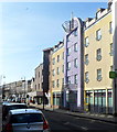
1
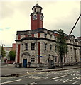
Llys Glas clock tower, Swansea
On the corner of Alexandra Road on the right and Orchard Street. Llys Glas, formerly the Central police station, is now in mixed use, including 80 units of student accommodation, artists' studios, Citizens Advice Bureau office, function rooms for hire and Tapestri Café Bar and Bistro.
Image: © Jaggery
Taken: 27 Apr 2014
0.02 miles
2
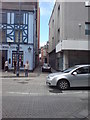
Across High street from King's Lane
The lane ahead connects with Orchard Street.
Image: © Deborah Tilley
Taken: 26 Jul 2008
0.02 miles
3
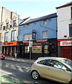
Adam & Eve, Swansea
High Street pub at number 207. https://www.geograph.org.uk/photo/2822383 to the name sign.
Image: © Jaggery
Taken: 26 Feb 2012
0.03 miles
4
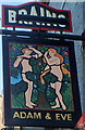
Adam & Eve pub sign, Swansea
Strategically-placed vegetation preserves the modesty of
Adam and Eve in the sign hanging from the wall of the High Street pub. http://www.geograph.org.uk/photo/2822370
Image: © Jaggery
Taken: 26 Feb 2012
0.03 miles
5
Mackworth Court, Swansea
The modern block of High Street flats occupies the site of The Angel Hotel, built in 1889. The Angel was later renamed the Mackworth Hotel, which closed in 1967 and was demolished in the 1970s.
Image: © Jaggery
Taken: 26 Feb 2012
0.03 miles
6
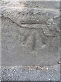
Ordnance Survey Bench Mark
This OS Bench Mark can be found on a building to the NW of Alexandra Rd. Formerly an 'Institute' building. Not on the OS Database but on the 1899 map. It marks a point 62.1ft (20.4m) above mean sea level.
Image: © Adrian Dust
Taken: 22 Jul 2013
0.04 miles
7
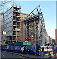
Major building work on a corner in central Swansea
The corner of Alexandra Road and Pleasant Street in early December 2013.
Image: © Jaggery
Taken: 6 Dec 2013
0.04 miles
8
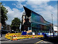
New and old, ALEX Design Exchange, Swansea
The corner of Alexandra Road and Pleasant Street viewed on September 12th 2014. Notices on the fenced-off site show Opening Autumn 2014.
The Swansea Open House website states that this new £14 million ALEX Design Exchange is home to the University of Wales Trinity Saint David’s award winning School of Industrial Design and Swansea School of Glass. Situated in Swansea’s arts quarter, the recently restored and extended Grade II listed former library is a mix of contemporary and traditional architecture, celebrating its historic position as a seat of learning dating back to 1887. This mixture of new and old continues inside with traditional design techniques and practices taught alongside modern cutting-edge technologies. The building is also home to the £4.7m Institute for Sustainable Design and Cerebra Innovation Centre, two leading research centres in the field of design and innovation.
Image: © Jaggery
Taken: 12 Sep 2014
0.04 miles
9
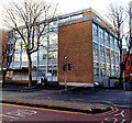
Trinity Building in central Swansea
Swansea NHS Trust Central Clinic on the corner of Orchard Street and Pleasant Street.
Image: © Jaggery
Taken: 6 Dec 2013
0.04 miles
10
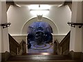
Nowhere Less Now
Approach to the 'Nowhere Less Now' exhibition by Lindsay Seers at the Glynn Vivian Art Gallery, Swansea.
Image: © Alan Hughes
Taken: 21 Feb 2017
0.04 miles