IMAGES TAKEN NEAR TO
Coedmawr, LLANELLI, SA15 5NT
Introduction
This page details the photographs taken nearby to Coedmawr, SA15 5NT by members of the Geograph project.
The Geograph project started in 2005 with the aim of publishing, organising and preserving representative images for every square kilometre of Great Britain, Ireland and the Isle of Man.

There are currently over 7.5m images from over14,400 individuals and you can help contribute to the project by visiting https://www.geograph.org.uk
Image Map (Loading...)


Getting Data...Please wait
Leaflet Map data © OpenStreetMap
Images are licensed for reuse under creativecommons.org/licenses/by-sa/2.0
Notes
- Clicking on the map will re-center to the selected point.
- The higher the marker number, the further away the image location is from the centre of the postcode.
Image Listing (5 Images Found)
Images are licensed for reuse under creativecommons.org/licenses/by-sa/2.0
Image
Details
Distance
3
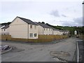
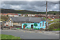
New housing development
A new housing development in Ponthenri called Ffynnon Y Waun.
Image: © Hywel Williams
Taken: 29 Sep 2006
0.16 miles
4
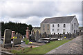
Chapel and graveyard on Heol y Pentre - Ponthenri
Image: © Mick Lobb
Taken: 7 Apr 2009
0.19 miles
5
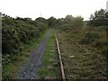
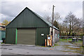
Old disused railway
Part of the Burry Port & Gwendraeth Valley railway, much of this line has now been lifted. It served passengers until 1953, but continued as a mineral line until 1996 when the line closed. It was considered for restoration, but the work to bring it back into operation was considerable and in the end it was closed.
Image: © Hywel Williams
Taken: 29 Sep 2006
0.24 miles