IMAGES TAKEN NEAR TO
Furnace, LLANELLI, SA15 4SA
Introduction
This page details the photographs taken nearby to SA15 4SA by members of the Geograph project.
The Geograph project started in 2005 with the aim of publishing, organising and preserving representative images for every square kilometre of Great Britain, Ireland and the Isle of Man.

There are currently over 7.5m images from over14,400 individuals and you can help contribute to the project by visiting https://www.geograph.org.uk
Image Map (Loading...)


Getting Data...Please wait
Leaflet Map data © OpenStreetMap
Images are licensed for reuse under creativecommons.org/licenses/by-sa/2.0
Notes
- Clicking on the map will re-center to the selected point.
- The higher the marker number, the further away the image location is from the centre of the postcode.
Image Listing (4 Images Found)
Images are licensed for reuse under creativecommons.org/licenses/by-sa/2.0
Image
Details
Distance
1
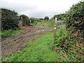
Llwybr ger Ffarm Bwlchyfedwen / Path near Bwlchyfedwen Farm
Llwybr cyhoeddus a Ffordd Sant Illtyd ger Ffarm Bwlchyfedwen.
A public footpath and the St Illtyd's Way near Bwlchyfedwen Farm (trans. pass of the birch tree).
Image: © Alan Richards
Taken: 9 Jul 2020
0.09 miles
2
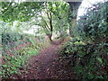
Llwybr ger Ffarm Bwlchyfedwen / Path near Bwlchyfedwen Farm
Llwybr cyhoeddus a Ffordd Sant Illtyd ger Ffarm Bwlchyfedwen.
A public footpath and the St Illtyd's Way near Bwlchyfedwen Farm (trans. pass of the birch tree).
Image: © Alan Richards
Taken: 9 Jul 2020
0.11 miles
3
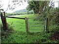
Llwybr Sant Illtyd / St Illtyd's Way
Llwybr Sant Illtyd yn mynd i lawr y cae i gyfeiriad y B4308.
The St Illtyd's Way descends the field towards the B4308.
Image: © Alan Richards
Taken: 9 Jul 2020
0.13 miles
4

Sharp bend approaching Llanelli
This was taken on an overcast winter's day- With better visibility it's possible to see the North side of the Gower; at the apex of the bend there is a turning to Pen-y-fai Lane.
Image: © Pan Dodd-Noble
Taken: 3 Jan 2008
0.18 miles