IMAGES TAKEN NEAR TO
LLANELLI, SA15 4NQ
Introduction
This page details the photographs taken nearby to SA15 4NQ by members of the Geograph project.
The Geograph project started in 2005 with the aim of publishing, organising and preserving representative images for every square kilometre of Great Britain, Ireland and the Isle of Man.

There are currently over 7.5m images from over14,400 individuals and you can help contribute to the project by visiting https://www.geograph.org.uk
Image Map (Loading...)


Getting Data...Please wait
Leaflet Map data © OpenStreetMap
Images are licensed for reuse under creativecommons.org/licenses/by-sa/2.0
Notes
- Clicking on the map will re-center to the selected point.
- The higher the marker number, the further away the image location is from the centre of the postcode.
Image Listing (3 Images Found)
Images are licensed for reuse under creativecommons.org/licenses/by-sa/2.0
Image
Details
Distance
1
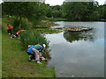
Furnace Pond
A Year 5 class from Penygaer Primary School on a science fieldtrip (studying a freshwater ecosystem) to Furnace Pond. The pond, once a reservoir for the town of Llanelli is now a favourite venue for walkers and fishermen (and budding scientists!), and is a haven for wildlife.
Image: © Anthony Stevenson
Taken: 10 Jul 2007
0.12 miles
2
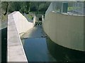
Spillway at Furnace Pond
The Reservoir here was opened in 1987 but this spillway is a more recent addition.
Image: © Nigel Davies
Taken: 2 Apr 2017
0.13 miles
3
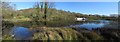
Furnace Pond, Llanelli
Also known as Tre-Beddrod Reservoir, this lake in the Furnace region of Llanelli has a car park and pleasant paths around it. The plaque says that the reservoir was built in 1987 but the white structure on the far shore is a more recent spillway at the southeast corner.
Image: © Nigel Davies
Taken: 2 Apr 2017
0.13 miles