IMAGES TAKEN NEAR TO
Maesycoed, LLANELLI, SA15 4EB
Introduction
This page details the photographs taken nearby to Maesycoed, SA15 4EB by members of the Geograph project.
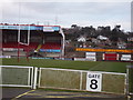
The Geograph project started in 2005 with the aim of publishing, organising and preserving representative images for every square kilometre of Great Britain, Ireland and the Isle of Man.

There are currently over 7.5m images from over14,400 individuals and you can help contribute to the project by visiting https://www.geograph.org.uk
Image Map (Loading...)


Getting Data...Please wait
Leaflet Map data © OpenStreetMap
Images are licensed for reuse under creativecommons.org/licenses/by-sa/2.0
Notes
- Clicking on the map will re-center to the selected point.
- The higher the marker number, the further away the image location is from the centre of the postcode.
Image Listing (29 Images Found)
Images are licensed for reuse under creativecommons.org/licenses/by-sa/2.0
Image
Details
Distance
1
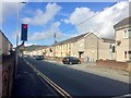
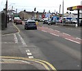
Road junction
Traffic lights at the road junction leading to Parc y Strade.
Image: © Alan Hughes
Taken: 16 Oct 2019
0.07 miles
2
Looking towards the SE corner of the former Stradey Park rugby ground, Llanelli
Viewed from the western end of Stradey Park Avenue. Stradey Park used to be the home ground of Llanelli Rugby Football Club, who moved to Parc y Scarlets http://www.geograph.org.uk/photo/1043074 in the Pemberton area of the town in November 2008.
Image: © Jaggery
Taken: 8 Apr 2012
0.07 miles
3
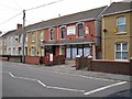
Former Sandy Gate newsagents
Located in Sandy Road. Note the GR wall post box mounted in its specially constructed brick pillar outside the shop.
Image: © Richard Dorrell
Taken: 17 Jun 2013
0.07 miles
4

Scarlets Home Ground
Back of the famous 9-3 (Llanelli-Seland Newydd) scoreboard!
Image: © Ronald John Saunders
Taken: 27 Jan 2007
0.10 miles
5
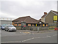
Sandy Community Hall
Located in Sandy Road.
Image: © Richard Dorrell
Taken: 17 Jun 2013
0.11 miles
6

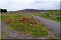
Stradey Park, Llanelli
How long will this be Llanelli's home ground?
Image: © Ronald John Saunders
Taken: 27 Jan 2007
0.11 miles
7
Llanelli Scarlets at Stradey Park
Will this be the home of Llanelli Rugby for much longer?
Image: © Ronald John Saunders
Taken: 27 Jan 2007
0.11 miles
8
Towards a bend in the A484, Sandy, Llanelli
Looking east towards the town centre along the A484 Sandy Road in the Sandy area of Llanelli.
Image: © Jaggery
Taken: 22 Mar 2018
0.13 miles
9
Eastern side of the former Stradey Park rugby ground, Llanelli
Viewed from the western end of Stradey Park Avenue. The distant bank is the edge of the disused Stradey Park, formerly the home ground of Llanelli Rugby Football Club, who moved to Parc y Scarlets http://www.geograph.org.uk/photo/1043074 in the Pemberton area of the town in November 2008.
Image: © Jaggery
Taken: 8 Apr 2012
0.14 miles
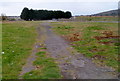
10
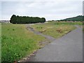
Former rugby club ground
The fenced area is the site of the former stands and pitch of the Llanelli Rugby Club. The club has now moved to new premises, and this site is about to be redeveloped as a housing estate.
Image: © Richard Dorrell
Taken: 17 Jun 2013
0.14 miles