IMAGES TAKEN NEAR TO
Spowart Avenue, LLANELLI, SA15 3HY
Introduction
This page details the photographs taken nearby to Spowart Avenue, SA15 3HY by members of the Geograph project.
The Geograph project started in 2005 with the aim of publishing, organising and preserving representative images for every square kilometre of Great Britain, Ireland and the Isle of Man.

There are currently over 7.5m images from over14,400 individuals and you can help contribute to the project by visiting https://www.geograph.org.uk
Image Map (Loading...)


Getting Data...Please wait
Leaflet Map data © OpenStreetMap
Images are licensed for reuse under creativecommons.org/licenses/by-sa/2.0
Notes
- Clicking on the map will re-center to the selected point.
- The higher the marker number, the further away the image location is from the centre of the postcode.
Image Listing (26 Images Found)
Images are licensed for reuse under creativecommons.org/licenses/by-sa/2.0
Image
Details
Distance
1
Rivet and arrow Park Howard west
LHS of gate entrance behind post Old Road.
Image: © John Jenkins
Taken: 13 Feb 2022
0.08 miles
2
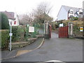
Parc Howard Entrance
There is an Ordnance Survey Rivet on the wall to the left of the entrance. http://www.geograph.org.uk/photo/4311482
Image: © Adrian Dust
Taken: 15 Jan 2015
0.09 miles
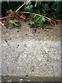
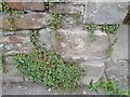
3
Ordnance Survey Rivet
This OS rivet can be found on the low wall to the left of the entrance to Parc Howard. It marks a point 33.65m above mean sea level. http://www.geograph.org.uk/photo/4311487
Image: © Adrian Dust
Taken: 15 Jan 2015
0.09 miles
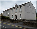
4
Llys-y-Coed care home, Llanelli
This is the northern side of a large residential care home
at 70-74 New Road, opposite the Stradey Park Avenue junction.
Image: © Jaggery
Taken: 8 Apr 2012
0.09 miles
5
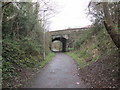
New Road Railway Bridge
There is an Ordnance Survey Cut Mark on the NW parapet. http://www.geograph.org.uk/photo/4311448
Image: © Adrian Dust
Taken: 15 Jan 2015
0.10 miles
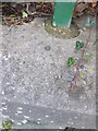
6
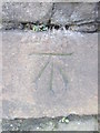
Ordnance Survey Cut Mark
This OS cut mark can be found on the NW parapet of the railway bridge. It marks a point 23.387m above mean sea level. http://www.geograph.org.uk/photo/4311490
Image: © Adrian Dust
Taken: 15 Jan 2015
0.10 miles
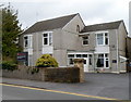
7
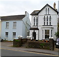
A late Victorian house, New Road, Llanelli
The detached house on the right has the year 1899 inscribed on the doorway arch.
Image: © Jaggery
Taken: 8 Apr 2012
0.16 miles
9
Ordnance Survey Cut Mark
This OS cut mark can be found on the wall NW side of Ynys-y-cwm Road. It marks a point 22.753m above mean sea level.
Image: © Adrian Dust
Taken: 28 Aug 2022
0.16 miles
10
Llanelli Centre For The Deaf
The registered charity's centre is at 54 New Road, Llanelli.
Image: © Jaggery
Taken: 8 Apr 2012
0.17 miles