IMAGES TAKEN NEAR TO
Albert Street, LLANELLI, SA15 2SY
Introduction
This page details the photographs taken nearby to Albert Street, SA15 2SY by members of the Geograph project.
The Geograph project started in 2005 with the aim of publishing, organising and preserving representative images for every square kilometre of Great Britain, Ireland and the Isle of Man.

There are currently over 7.5m images from over14,400 individuals and you can help contribute to the project by visiting https://www.geograph.org.uk
Image Map (Loading...)


Getting Data...Please wait
Leaflet Map data © OpenStreetMap
Images are licensed for reuse under creativecommons.org/licenses/by-sa/2.0
Notes
- Clicking on the map will re-center to the selected point.
- The higher the marker number, the further away the image location is from the centre of the postcode.
Image Listing (46 Images Found)
Images are licensed for reuse under creativecommons.org/licenses/by-sa/2.0
Image
Details
Distance
2
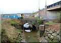
Lliedi resurfaces
This is the point where the river Lliedi re-emerges after travelling for about 700m underground through the centre of Llanelli. Much of Llanelli is very near sea level and about 20m downstream, the river starts to be influenced by normal high tides.
Image: © Hywel Williams
Taken: 18 Oct 2006
0.09 miles
3
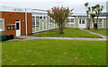
The Palms Centre, Llanelli
Two of the occupiers of The Palms Centre, 96 Queen Victoria Road, are R.T.Electrics on the right and the CYCA Wales Training Centre on the left. CYCA (Carmarthenshire Youth and Children's Association) is a registered children's charity operating throughout the county of Carmarthenshire. CYCA provides informal educational and recreational activities for children and young people, and support for families.
Image: © Jaggery
Taken: 8 Apr 2012
0.10 miles
4
The Coastal Park Guest Accommodation and Grill, Llanelli
Located at the southern end of Queen Victoria Road, near the Millennium Coastal Park. Formerly two guesthouses, The Victoria on the left, now the Coastal Park's Grill, and Awel Y Mor on the right, now the main accommodation section of The Coastal Park hotel.
Image: © Jaggery
Taken: 8 Apr 2012
0.10 miles
5
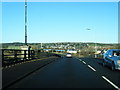
Arriva Trains Wales train crosses the Afon Lliedi, Llanelli
The location is about 700 metres NW of Llanelli railway station. http://www.geograph.org.uk/photo/2892870
Image: © Jaggery
Taken: 8 Apr 2012
0.11 miles
6
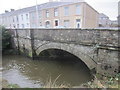
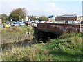
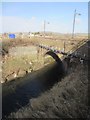
Afon Lliedi Bridge
There is an OS cut mark on the north parapet. http://www.geograph.org.uk/photo/3840590
Image: © Adrian Dust
Taken: 8 Feb 2014
0.12 miles
7
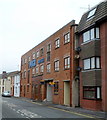
Queens Lofts, Llanelli
Queens Lofts are flats in Princess Street, occupying the converted former Pugh Brothers warehouse and factory. The PUGH BROTHERS name remains on the building. In the 1950s, after a fire here which destroyed all their machinery, Pugh Brothers discontinued making furniture, and instead bought in ready-made furniture from outside manufacturers. Pugh Brothers continued in their Cowell Street premises until closure in the early 21st century.
Image: © Jaggery
Taken: 8 Apr 2012
0.12 miles
8
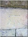
Ordnance Survey Cut Mark
This OS cut mark can be found on the south parapet of the bridge over the River Lliedi. It marks a point 8.0924m above mean sea level. http://www.geograph.org.uk/photo/3865868
Image: © Adrian Dust
Taken: 27 Feb 2014
0.12 miles
9
River Lliedi Bridge
There is an OS cut mark on the south parapet. http://www.geograph.org.uk/photo/3865864
Image: © Adrian Dust
Taken: 27 Feb 2014
0.12 miles
10
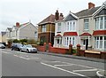
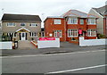
Houses near the southern end of Queen Victoria Road, Llanelli
Viewed from the corner of Albert Street. The bilingual street name sign on the right shows Victoria in the Welsh part of the name, which is surprising as V is not in the Welsh alphabet. I expected to see Fictoria, or Buddug, which is used as the Welsh form of Victoria on street signs in some parts of Wales, as here. http://www.geograph.org.uk/photo/2137697
Image: © Jaggery
Taken: 8 Apr 2012
0.12 miles