IMAGES TAKEN NEAR TO
Glanmor Terrace, LLANELLI, SA15 2RD
Introduction
This page details the photographs taken nearby to Glanmor Terrace, SA15 2RD by members of the Geograph project.
The Geograph project started in 2005 with the aim of publishing, organising and preserving representative images for every square kilometre of Great Britain, Ireland and the Isle of Man.

There are currently over 7.5m images from over14,400 individuals and you can help contribute to the project by visiting https://www.geograph.org.uk
Image Map (Loading...)


Getting Data...Please wait
Leaflet Map data © OpenStreetMap
Images are licensed for reuse under creativecommons.org/licenses/by-sa/2.0
Notes
- Clicking on the map will re-center to the selected point.
- The higher the marker number, the further away the image location is from the centre of the postcode.
Image Listing (112 Images Found)
Images are licensed for reuse under creativecommons.org/licenses/by-sa/2.0
Image
Details
Distance
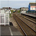
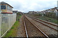
1
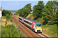
Railway at Llanelli
From the footbridge on Glanmor Terrace.
Image: © Wayland Smith
Taken: 4 Sep 2021
0.08 miles
2
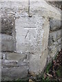
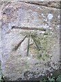
Ordnance Survey Cut Mark
This OS cut mark can be found on the East angle of St Peter's Church. It marks a point 9.2141m above mean sea level.
Image: © Adrian Dust
Taken: 27 Feb 2014
0.09 miles
4
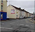
Railway Terrace, Llanelli
Viewed from Glanmor Road. A dark blue part of Once Upon a Time Day Nursery http://www.geograph.org.uk/photo/2890755 is on the left.
Image: © Jaggery
Taken: 20 Aug 2015
0.09 miles
5
Ordnance Survey Cut Mark
This OS cut mark can be found on the gatepost of Lakefield Road School. It marks a point 8.5253m above mean sea level.
Image: © Adrian Dust
Taken: 27 Feb 2014
0.09 miles
6
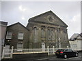
Calvanistic Methodist Siloh Chapel
Lakefield Road.
Image: © Adrian Dust
Taken: 27 Feb 2014
0.12 miles
7
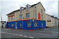
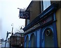
Once Upon a Time Day Nursery, Llanelli
Located at 56 Railway Terrace, on the corner of Glanmor Road adjacent to the level crossing
at the western end of Llanelli railway station.
Image: © Jaggery
Taken: 8 Apr 2012
0.13 miles
8
Milford Haven train viewed from Llanelli station
An Arriva Trains Wales service to Milford Haven via Whitland and Haverfordwest
has just crossed the Glanmor Road level crossing on the west side of Llanelli station.
Image: © Jaggery
Taken: 1 May 2015
0.13 miles
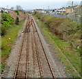
9
Railway lines west of Glanmor Road level crossing, Llanelli
Llanelli railway station is immediately behind the camera. The lines head west past Llanelli West Ground Frame http://www.geograph.org.uk/photo/2890787 on the left. The next station ahead is Pembrey and Burry Port station, about 6 km away.
Image: © Jaggery
Taken: 8 Apr 2012
0.13 miles
10
Looking towards Llanelli railway station from Queen Victoria Road bridge
The station is about 600 metres ahead. A plaque http://www.geograph.org.uk/photo/2945443 on the bridge records that two fatalities occurred here during the 1911 National Railway Strike.
Image: © Jaggery
Taken: 8 Apr 2012
0.14 miles