IMAGES TAKEN NEAR TO
Bryn Place, LLANELLI, SA15 2PE
Introduction
This page details the photographs taken nearby to Bryn Place, SA15 2PE by members of the Geograph project.
The Geograph project started in 2005 with the aim of publishing, organising and preserving representative images for every square kilometre of Great Britain, Ireland and the Isle of Man.

There are currently over 7.5m images from over14,400 individuals and you can help contribute to the project by visiting https://www.geograph.org.uk
Image Map
Images are licensed for reuse under creativecommons.org/licenses/by-sa/2.0
Notes
- Clicking on the map will re-center to the selected point.
- The higher the marker number, the further away the image location is from the centre of the postcode.
Image Listing (71 Images Found)
Images are licensed for reuse under creativecommons.org/licenses/by-sa/2.0
Image
Details
Distance
1
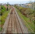
Looking towards Llanelli railway station from Queen Victoria Road bridge
The station is about 600 metres ahead. A plaque http://www.geograph.org.uk/photo/2945443 on the bridge records that two fatalities occurred here during the 1911 National Railway Strike.
Image: © Jaggery
Taken: 8 Apr 2012
0.02 miles
2
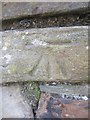
Ordnance Survey Cut Mark
This OS cut mark can be found on the boundary wall of No36 Nelson Street. It marks a point 6.9433m above mean sea level.
Image: © Adrian Dust
Taken: 27 Feb 2014
0.07 miles
3
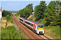
Railway at Llanelli
From the footbridge on Glanmor Terrace.
Image: © Wayland Smith
Taken: 4 Sep 2021
0.09 miles
4
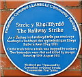
1911 Railway Strike fatalities plaque, Llanelli
The Llanelli Community Heritage blue plaque is on the side of the Queen Victoria Road bridge across railway lines. It records that on Saturday August 19th, 1911 during a railway strike, a train was stopped by strikers on the track below. http://www.geograph.org.uk/photo/2945466 Two bystanders were shot and killed by troops.
It was the last time troops on the British mainland fired on workers during an industrial dispute.
The strike, the first national railway strike in the UK, occurred during a long period of industrial unrest known as the Great Unrest of 1910 to 1914.
Image: © Jaggery
Taken: 8 Apr 2012
0.09 miles
5
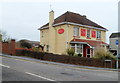
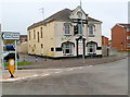
The Bay bar & bistro, Llanelli
On the corner of Victoria Square and Bryn Road. The building was formerly the Union Inn.
Image: © Jaggery
Taken: 8 Apr 2012
0.09 miles
6
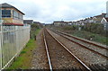
Railway lines west of Glanmor Road level crossing, Llanelli
Llanelli railway station is immediately behind the camera. The lines head west past Llanelli West Ground Frame http://www.geograph.org.uk/photo/2890787 on the left. The next station ahead is Pembrey and Burry Port station, about 6 km away.
Image: © Jaggery
Taken: 8 Apr 2012
0.09 miles
7
Victoria Road Methodist Church, Llanelli
Image: © Eirian Evans
Taken: 22 May 2022
0.10 miles
8
Hope and Anchor, Llanelli
Pub, 13 Cambrian Street.
Image: © Jaggery
Taken: 8 Apr 2012
0.11 miles
9
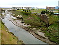
Abandoned boat on a bank of the Afon Lliedi, Llanelli
Judging by the accumulated mud on the vessel, the boat has not been used in a long time.
Image: © Jaggery
Taken: 8 Apr 2012
0.11 miles
10
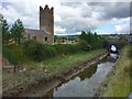
Afon Lliedi
The Afon Lliedi near its mouth at the Loughor Estuary.
On its journey to the sea it has filled two reservoirs and has flowed through the brewery at Felinfoel, no doubt helping to create the internationally acclaimed Felinfoel fraught beer.
Image: © Alan Hughes
Taken: 7 Sep 2018
0.12 miles