IMAGES TAKEN NEAR TO
Marged Street, LLANELLI, SA15 2EP
Introduction
This page details the photographs taken nearby to Marged Street, SA15 2EP by members of the Geograph project.
The Geograph project started in 2005 with the aim of publishing, organising and preserving representative images for every square kilometre of Great Britain, Ireland and the Isle of Man.

There are currently over 7.5m images from over14,400 individuals and you can help contribute to the project by visiting https://www.geograph.org.uk
Image Map (Loading...)


Getting Data...Please wait
Leaflet Map data © OpenStreetMap
Images are licensed for reuse under creativecommons.org/licenses/by-sa/2.0
Notes
- Clicking on the map will re-center to the selected point.
- The higher the marker number, the further away the image location is from the centre of the postcode.
Image Listing (160 Images Found)
Images are licensed for reuse under creativecommons.org/licenses/by-sa/2.0
Image
Details
Distance
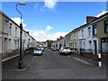
1

Marged Street, Llanelli
Dead-end street on the south side of Copperworks Road.
Image: © Jaggery
Taken: 6 Aug 2015
0.00 miles
2
Marged Street, Llanelli
Viewed from the lane at the southern end of the street, looking towards Copperworks Road.
Image: © Jaggery
Taken: 15 Aug 2015
0.03 miles
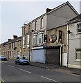
3
Llanelli Docks post office
Located at 3 New Dock Road, near the eastern edge of Llanelli railway station. http://www.geograph.org.uk/photo/2892869
Image: © Jaggery
Taken: 8 Apr 2012
0.03 miles
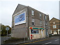
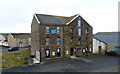
4
Alex's Hair & Beauty salon, Llanelli
At 4 New Dock Road, near the corner of Copperworks Road.
Image: © Jaggery
Taken: 1 May 2015
0.04 miles
5
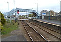
Footbridge and level crossing at the eastern end of Llanelli railway station
Viewed from platform 2. Station Road north of the level crossing is renamed New Dock Road south of the level crossing. There is another level crossing http://www.geograph.org.uk/photo/2890797 at the opposite end of the station.
Image: © Jaggery
Taken: 8 Apr 2012
0.04 miles
6
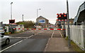
Level crossing at the eastern end of Llanelli railway station
Viewed from Station Road, which is renamed New Dock Road on the far side of the level crossing.
The barriers were lowered a few minutes before the passage of a train across the road. Pedestrians can use the footbridge http://www.geograph.org.uk/photo/2892868 on the right when the barriers are down.
Image: © Jaggery
Taken: 8 Apr 2012
0.04 miles
7
Dance Kingdom, Llanelli
Dancers' club and school of dancing, located in Pharaoh House, Station Yard, New Dock Road.
Viewed from a footbridge. http://www.geograph.org.uk/photo/2892868
Image: © Jaggery
Taken: 8 Apr 2012
0.04 miles
8
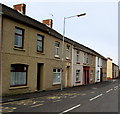
Copperworks Road houses, Llanelli
On the south side of Copperworks Road, viewed across a bus stop from the corner of New Dock Road.
The left turn ahead is into Marged Street.
Image: © Jaggery
Taken: 1 May 2015
0.04 miles
9
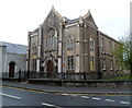
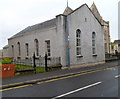
Trinity chapel, New Dock Road, Llanelli
Located on the corner of New Dock Road and Trinity Road.
The chapel is an 1867 rebuild of the original, built in 1858 as a Calvinistic Methodist chapel.
Image: © Jaggery
Taken: 8 Apr 2012
0.05 miles
10
Trinity schoolroom, New Dock Road, Llanelli
Located alongside Trinity chapel. http://www.geograph.org.uk/photo/2892965
Image: © Jaggery
Taken: 8 Apr 2012
0.05 miles