IMAGES TAKEN NEAR TO
Y Bwthyn, LLANELLI, SA15 1RS
Introduction
This page details the photographs taken nearby to Y Bwthyn, SA15 1RS by members of the Geograph project.
The Geograph project started in 2005 with the aim of publishing, organising and preserving representative images for every square kilometre of Great Britain, Ireland and the Isle of Man.

There are currently over 7.5m images from over14,400 individuals and you can help contribute to the project by visiting https://www.geograph.org.uk
Image Map
Images are licensed for reuse under creativecommons.org/licenses/by-sa/2.0
Notes
- Clicking on the map will re-center to the selected point.
- The higher the marker number, the further away the image location is from the centre of the postcode.
Image Listing (77 Images Found)
Images are licensed for reuse under creativecommons.org/licenses/by-sa/2.0
Image
Details
Distance
1
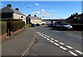
East along Firth Road, Llanelli
From the Bigyn Road junction.
Image: © Jaggery
Taken: 10 Mar 2016
0.05 miles
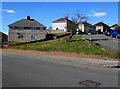
2
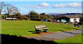
Y Bwthyn benches, Llanelli
Located in a grassy area between Y Bwthyn Care Home http://www.geograph.org.uk/photo/4866035 and a side road name Y Bwthyn.
Image: © Jaggery
Taken: 10 Mar 2016
0.05 miles
3
From Bigyn Road to Firth Road, Llanelli
The street name sign on the left shows HEOL BIGYN/BIGYN ROAD.
The street name sign on the right shows HEOL FIRTH/FIRTH ROAD.
Image: © Jaggery
Taken: 10 Mar 2016
0.05 miles
4
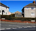
Y Bwthyn, Llanelli
The SW end of Y Bwthyn, viewed across Bigyn Road.
Y Bwthyn is a side road leading to Queen Mary's Walk, about 170 metres to the east.
Image: © Jaggery
Taken: 10 Mar 2016
0.06 miles
5
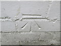
Ordnance Survey Cut Mark
This OS cut mark can be found on No29 Firth Road. It marks a point 27.432m above mean sea level.
Image: © Adrian Dust
Taken: 20 Jul 2014
0.06 miles
6
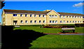
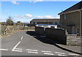
Southeast side of Y Bwthyn Care Home, Llanelli
Extending for 60 metres (about 200 ft). Viewed from the corner of Bigyn Road and the road named Y Bwthyn.
Image: © Jaggery
Taken: 10 Mar 2016
0.06 miles
7
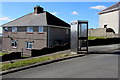
BT phonebox, Bigyn Road, Llanelli
At the northern edge of a grass triangle, partly visible behind the tree here. http://www.geograph.org.uk/photo/4862788
Image: © Jaggery
Taken: 10 Mar 2016
0.07 miles
8
Tree-lined entrance to Y Bwthyn Care Home, Llanelli
From Bigyn Road.
Image: © Jaggery
Taken: 10 Mar 2016
0.07 miles
9
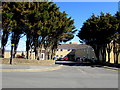
Grass triangle at a Llanelli junction
At the junction of Firth Road and Bigyn Road.
Image: © Jaggery
Taken: 10 Mar 2016
0.07 miles
10
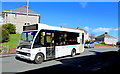
Carmarthenshire Dial-a-Bus in Tyisha Road, Llanelli
The Carmarthenshire Dial-a-Bus (Bws Bach Sir Gâr in Welsh) responds to the requests of passengers by changing route to pick them up at home. Although the bus operates on a fixed route and to set times, people living nearby can phone a special number to arrange for it to pick them up outside their front door.
Image: © Jaggery
Taken: 10 Mar 2016
0.08 miles