IMAGES TAKEN NEAR TO
Grant Street, LLANELLI, SA15 1RB
Introduction
This page details the photographs taken nearby to Grant Street, SA15 1RB by members of the Geograph project.
The Geograph project started in 2005 with the aim of publishing, organising and preserving representative images for every square kilometre of Great Britain, Ireland and the Isle of Man.

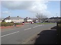
There are currently over 7.5m images from over14,400 individuals and you can help contribute to the project by visiting https://www.geograph.org.uk
Image Map
Images are licensed for reuse under creativecommons.org/licenses/by-sa/2.0
Notes
- Clicking on the map will re-center to the selected point.
- The higher the marker number, the further away the image location is from the centre of the postcode.
Image Listing (26 Images Found)
Images are licensed for reuse under creativecommons.org/licenses/by-sa/2.0
Image
Details
Distance
1
Pen-Y-Fan, Llanelli
The area of Pen-Y-Fan used to be a large estate of council houses, however most of the houses are today owned by their occupiers.
Image: © Hywel Williams
Taken: 7 Mar 2007
0.08 miles
2
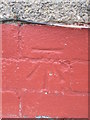
Ordnance Survey Cut Mark
This OS cut mark can be found on No1 Grant Street. It marks a point 27.274m above mean sea level.
Image: © Adrian Dust
Taken: 20 Jul 2014
0.09 miles
3
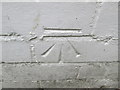
Ordnance Survey Cut Mark
This OS cut mark can be found on No29 Firth Road. It marks a point 27.432m above mean sea level.
Image: © Adrian Dust
Taken: 20 Jul 2014
0.11 miles
4
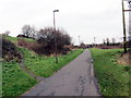
Hen dramffordd / Former tram-road
Mae'r hen dramffordd lofaol, a arweiniai at sawl pwll glo, bellach yn llwybr cyhoeddus.
A former colliery tram-road, which served several pits, is today a public footpath.
Image: © Alan Richards
Taken: 30 Jan 2018
0.12 miles
5
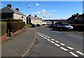
East along Firth Road, Llanelli
From the Bigyn Road junction.
Image: © Jaggery
Taken: 10 Mar 2016
0.13 miles
6
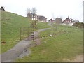
Pointless kissing gate
There were three identical kissing kates is sequence along the main path here. today, they seem utterly pointless, but there was some evidence of some form of boundary there at one time.
Years ago, I'm told that this area was known as Rocky Path - but these days the path is paved and a recognised cycle route.
Image: © Hywel Williams
Taken: 10 Mar 2007
0.14 miles
7
From Bigyn Road to Firth Road, Llanelli
The street name sign on the left shows HEOL BIGYN/BIGYN ROAD.
The street name sign on the right shows HEOL FIRTH/FIRTH ROAD.
Image: © Jaggery
Taken: 10 Mar 2016
0.17 miles
8
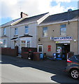
Off licence and shop, Tyisha Road, Llanelli
The shop at 54 Tyisha Road was formerly a sub post office.
The post office counter, minus the glass screen, remains in the shop in March 2016.
Image: © Jaggery
Taken: 10 Mar 2016
0.19 miles
9
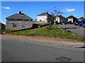
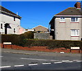
Grass triangle at a Llanelli junction
At the junction of Firth Road and Bigyn Road.
Image: © Jaggery
Taken: 10 Mar 2016
0.19 miles
10
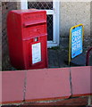
Queen Elizabeth II postbox outside a former post office, Tyisha Road, Llanelli
Behind the litter bin here. http://www.geograph.org.uk/photo/4862801
Image: © Jaggery
Taken: 10 Mar 2016
0.19 miles