IMAGES TAKEN NEAR TO
Penyfan Road, LLANELLI, SA15 1JJ
Introduction
This page details the photographs taken nearby to Penyfan Road, SA15 1JJ by members of the Geograph project.
The Geograph project started in 2005 with the aim of publishing, organising and preserving representative images for every square kilometre of Great Britain, Ireland and the Isle of Man.

There are currently over 7.5m images from over14,400 individuals and you can help contribute to the project by visiting https://www.geograph.org.uk
Image Map
Images are licensed for reuse under creativecommons.org/licenses/by-sa/2.0
Notes
- Clicking on the map will re-center to the selected point.
- The higher the marker number, the further away the image location is from the centre of the postcode.
Image Listing (16 Images Found)
Images are licensed for reuse under creativecommons.org/licenses/by-sa/2.0
Image
Details
Distance
1
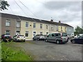
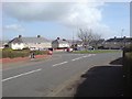
Terraced houses
A row of terraced houses near Parc Trostre, Llanelli.
Image: © Alan Hughes
Taken: 26 Jun 2019
0.07 miles
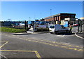
2
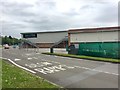
Parc Trostre
Industrial units at Parc Trostre, Llanelli.
Image: © Alan Hughes
Taken: 26 Jun 2019
0.15 miles
4
Ordnance Survey Cut Mark
This OS cut mark can be found on the south angle of Llanelli Grammar School. It marks a point 23.622m above mean sea level.
Image: © Adrian Dust
Taken: 20 Jul 2014
0.17 miles
5
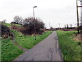
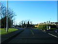
Hen dramffordd / Former tram-road
Mae'r hen dramffordd lofaol, a arweiniai at sawl pwll glo, bellach yn llwybr cyhoeddus.
A former colliery tram-road, which served several pits, is today a public footpath.
Image: © Alan Richards
Taken: 30 Jan 2018
0.19 miles
6
Y Llwyn bungalows, Llanelli
Part of a side arm of Y Llwyn, aligned at right angles to the main course of Y Llwyn.
Image: © Jaggery
Taken: 10 Mar 2016
0.21 miles
7
Ysgol Coedcae (Coedcae School) entrance, Llanelli
This entrance is from Coed Cae Road.
Image: © Jaggery
Taken: 10 Mar 2016
0.21 miles
8
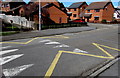
Zigzag yellow markings on a Coed Cae Road speed bump, Llanelli
The yellow markings are part of the Keep Clear (no stopping or parking) Zone
outside this http://www.geograph.org.uk/photo/5262248 entrance to Ysgol Coedcae (Coedcae School).
Image: © Jaggery
Taken: 10 Mar 2016
0.21 miles
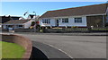
9
Pen-Y-Fan, Llanelli
The area of Pen-Y-Fan used to be a large estate of council houses, however most of the houses are today owned by their occupiers.
Image: © Hywel Williams
Taken: 7 Mar 2007
0.21 miles
10
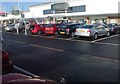
New development at Parc Trostre
M+S - one of many big names that have followed the national trend of vacating the town centres without a backward glance. Parc Trostre is the new Llanelli. Luckily the 'old' Llanelli seems to be holding strong, but has definitely acquired a slightly different feel since the exodus took hold.
Image: © Deborah Tilley
Taken: 18 Jan 2009
0.23 miles