IMAGES TAKEN NEAR TO
Llwyn Cyfarthwch, LLANELLI, SA15 1GY
Introduction
This page details the photographs taken nearby to Llwyn Cyfarthwch, SA15 1GY by members of the Geograph project.
The Geograph project started in 2005 with the aim of publishing, organising and preserving representative images for every square kilometre of Great Britain, Ireland and the Isle of Man.

There are currently over 7.5m images from over14,400 individuals and you can help contribute to the project by visiting https://www.geograph.org.uk
Image Map
Images are licensed for reuse under creativecommons.org/licenses/by-sa/2.0
Notes
- Clicking on the map will re-center to the selected point.
- The higher the marker number, the further away the image location is from the centre of the postcode.
Image Listing (38 Images Found)
Images are licensed for reuse under creativecommons.org/licenses/by-sa/2.0
Image
Details
Distance
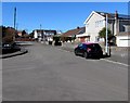
1
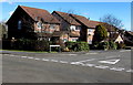
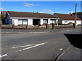
Llwyncyfarthwch houses, Llanelli
Houses near the Coed Cae Road end of the cul-de-sac named Llwyncyfarthwch, http://www.geograph.org.uk/photo/5262339
which must be a candidate for the longest one-word street name in Llanelli.
Image: © Jaggery
Taken: 10 Mar 2016
0.04 miles
2
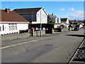
Y Llwyn houses, Llanelli
Y Llwyn is a cul-de-sac on the east side of Coed Cae Road.
Image: © Jaggery
Taken: 10 Mar 2016
0.05 miles
3
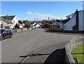
Towards the southeast end of Y Llwyn, Llanelli
Y Llwyn is a cul-de-sac extending for about 100 metres from the SE side of Coed Cae Road.
A short side arm is on the right. http://www.geograph.org.uk/photo/5262290
Image: © Jaggery
Taken: 10 Mar 2016
0.05 miles
4
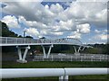
Pont Bennett in over the A484 in Trostre, Llanelli
A new footbridge completed in August named 'Pont Bennett', after the legendary rugby player. It begins near the Halfway pub and ends by the New Dock Stars rugby pitch.
Image: © CapG
Taken: 2 Sep 2023
0.06 miles
5
Y Llwyn bungalows, Llanelli
Y Llwyn is a cul-de-sac on the east side of Coed Cae Road.
Image: © Jaggery
Taken: 10 Mar 2016
0.06 miles
6
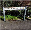
Llwyncyfarthwch name sign, Llanelli
Located here. http://www.geograph.org.uk/photo/5262326
In Llanelli, some name signs are in English only, some in Welsh only.
Many are bilingual. This Welsh-only sign ought to be bilingual,
for the benefit of those who don't speak Welsh....
Image: © Jaggery
Taken: 10 Mar 2016
0.07 miles
7
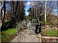
Southern end of an A484 footbridge, Llanelli
The footbridge gives walkers and cyclists access between the two halves of Coed Cae Road, severed by the construction of the current route of the A484. The earlier route of the A484 in Llanelli is now the B4297.
Image: © Jaggery
Taken: 10 Mar 2016
0.07 miles
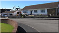
8
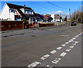
Coed Cae Road houses, Llanelli
On the north side of the Y Llwyn junction.
Image: © Jaggery
Taken: 10 Mar 2016
0.08 miles
9
Y Llwyn towards Coed Cae Road, Llanelli
Looking NW along the cul-de-sac named Y Llwyn towards Coed Cae Road.
A short side arm of Y Llwyn is on the left. http://www.geograph.org.uk/photo/5262290
Image: © Jaggery
Taken: 10 Mar 2016
0.08 miles
10
Y Llwyn bungalows, Llanelli
Part of a side arm of Y Llwyn, aligned at right angles to the main course of Y Llwyn.
Image: © Jaggery
Taken: 10 Mar 2016
0.09 miles