IMAGES TAKEN NEAR TO
Pendderi Road, LLANELLI, SA14 9PW
Introduction
This page details the photographs taken nearby to Pendderi Road, SA14 9PW by members of the Geograph project.
The Geograph project started in 2005 with the aim of publishing, organising and preserving representative images for every square kilometre of Great Britain, Ireland and the Isle of Man.

There are currently over 7.5m images from over14,400 individuals and you can help contribute to the project by visiting https://www.geograph.org.uk
Image Map
Images are licensed for reuse under creativecommons.org/licenses/by-sa/2.0
Notes
- Clicking on the map will re-center to the selected point.
- The higher the marker number, the further away the image location is from the centre of the postcode.
Image Listing (5 Images Found)
Images are licensed for reuse under creativecommons.org/licenses/by-sa/2.0
Image
Details
Distance
1
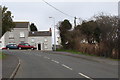
Road junction in Station Road, Bynea
Image: © Ruth Sharville
Taken: 21 Feb 2009
0.09 miles
2
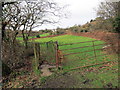
Llwybr Heol Saron / Saron Road Path
Llwybr cyhoeddus yn mynd i gyfeiriad Heol Saron.
A public footpath heading in the direction of Saron Road
Image: © Alan Richards
Taken: 30 Jan 2018
0.11 miles
3
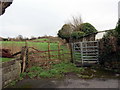
Llwybr Heol yr Orsaf / Station Road Path
Llwybr cyhoeddus yn mynd i gyfeiriad Heol yr Orsaf.
A public footpath heading in the direction of Station Road
Image: © Alan Richards
Taken: 30 Jan 2018
0.19 miles
4

Ysgol y Bynea/Bynea Primary School
Viewed across Saron Road in Bynea. The school website states that Ysgol y Bynea provides mainstream education for pupils aged 3-11. The school is a County Primary Co-Educational Day school which adopts the L.E.A.'s Welsh Language Policy for primary schools. The school falls into Category B/ Category 5 with education in English. Welsh is taught as a second language. The predominant language spoken at home is English.
The original Victorian school, situated alongside the main road through the village, was built in 1897. It has been converted to housing for the elderly. The school buildings seen here, situated off the main road, opened in 1976.
Image: © Jaggery
Taken: 17 Mar 2016
0.21 miles
5
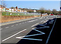
Zigzag markings on Saron Road, Bynea
Marking a Keep Clear Zone outside Ysgol y Bynea/Bynea Primary School. http://www.geograph.org.uk/photo/4908915
Image: © Jaggery
Taken: 17 Mar 2016
0.24 miles