1
Fenced-off building, Bynea
Viewed across Cwmfelin Road in mid March 2016 when building work is in progress on the building on the corner of Saron Road. Names in view here in an August 2011 Google Earth Street View were Barbucci, The Club Bynea and Home of Bynea RFC (Rugby Football Club).
Image: © Jaggery
Taken: 17 Mar 2016
0.02 miles
2
Cwmfelin Road bus stop and shelter, Bynea
This side of the road for buses to Loughor, Gorseinon and Swansea.
Image: © Jaggery
Taken: 17 Mar 2016
0.03 miles
3
Information board, Bynea
Located behind this http://www.geograph.org.uk/photo/4992682 Cwmfelin Road bus shelter, the large board displays illustrated historical, geological and geographical information about Bynea and the surrounding area.
Image: © Jaggery
Taken: 17 Mar 2016
0.03 miles
4
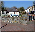
Public area in Bynea
Part of a roughly triangular site between the B4297 Cwmfelin Road and Saron Road.
Image: © Jaggery
Taken: 17 Mar 2016
0.04 miles
5
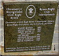
Bynea Rugby Club Internationals plaque
Located here http://www.geograph.org.uk/photo/4992839 the plaque records the names of the seven Bynea Rugby Club players who have played for Wales. One of them, Terry Davies, also played for the British Lions.
Image: © Jaggery
Taken: 17 Mar 2016
0.04 miles
6
Rugby plaque on a Bynea wall
Located in this http://www.geograph.org.uk/photo/4992772 public area, the plaque http://www.geograph.org.uk/photo/4992834 records the names of Bynea Rugby Club players who have played for Wales.
Image: © Jaggery
Taken: 17 Mar 2016
0.04 miles
7
Former BT phonebox, Bynea
In March 2016, there is no telephone in the grey box on the corner of Saron Road and Cwmfelin Road.
Image: © Jaggery
Taken: 17 Mar 2016
0.05 miles
8
Ysgol y Bynea/Bynea Primary School Croeso/Welcome board
The Welcome board facing the B4297 is alongside Saron Road on the approach to this http://www.geograph.org.uk/photo/4908915 school.
Image: © Jaggery
Taken: 17 Mar 2016
0.05 miles
9
Junction of the B4297 and Saron Road, Bynea
Looking along Saron Road towards Ysgol y Bynea/Bynea Primary School. http://www.geograph.org.uk/photo/4908915
Image: © Jaggery
Taken: 17 Mar 2016
0.05 miles
10
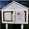
Information board outside Saron Community Hall, Bynea
The board on the left here http://www.geograph.org.uk/photo/4992715 is displaying a Bynea and Llwynhendy History Society notice and a Local Energy Action notice on March 17th 2016.
Image: © Jaggery
Taken: 17 Mar 2016
0.05 miles


