IMAGES TAKEN NEAR TO
Tir Yr Yspyty, LLANELLI, SA14 9AZ
Introduction
This page details the photographs taken nearby to Tir Yr Yspyty, SA14 9AZ by members of the Geograph project.
The Geograph project started in 2005 with the aim of publishing, organising and preserving representative images for every square kilometre of Great Britain, Ireland and the Isle of Man.

There are currently over 7.5m images from over14,400 individuals and you can help contribute to the project by visiting https://www.geograph.org.uk
Image Map
Images are licensed for reuse under creativecommons.org/licenses/by-sa/2.0
Notes
- Clicking on the map will re-center to the selected point.
- The higher the marker number, the further away the image location is from the centre of the postcode.
Image Listing (45 Images Found)
Images are licensed for reuse under creativecommons.org/licenses/by-sa/2.0
Image
Details
Distance
1
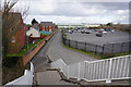
Tir yr Yspyty
A road on the west side of the Loughor river ujsed briefly by Cycle Route 4 and the Wales Coast Path.
Image: © Bill Boaden
Taken: 6 Apr 2016
0.05 miles
2
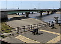
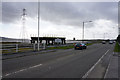
Loughor Bridge
Carrying the A484 over the River Loughor into Glamorgan.
Image: © Bill Boaden
Taken: 6 Apr 2016
0.06 miles
3
Across Loughor Bridge from South Wales to West Wales
The midpoint of the River Loughor here marks the boundary between the City and County of Swansea in South Wales (on this side) and Carmarthenshire in West Wales. A minor difference noticed by this observer is that bilingual signs on this side show English first (such as School/Ysgol) whereas in Carmarthenshire, Welsh is first (Ysgol/School).
Image: © Jaggery
Taken: 25 Mar 2016
0.06 miles
4
The A484 entering Carmarthenshire
The road has just crossed Loughor Bridge and the Loughor Estuary still extends to the left.
Image: © Bill Boaden
Taken: 6 Apr 2016
0.06 miles
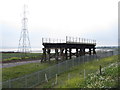
5
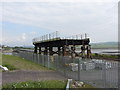
Preserved section of the old Loughor Viaduct
Image: © Gareth James
Taken: 31 May 2014
0.07 miles
6
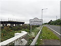
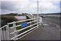
Croeso i Sir Gaerfyrddin
This sign is on the western side of the Loughor Bridge. To the left is a section of the Loughor Viaduct - this short section of the original viaduct was lifted from the riverbed and mounted, high and dry, at a strategic point near the main Swansea-Llanelli highway, where it is now a place of pilgrimage for fans of railway engineering. This Victorian remnant is in a protective compound between the road and the rail line it used to serve, and an information board in English and Welsh provides a full account of the history of the viaduct. https://www.atlasobscura.com/places/loughor-viaduct
Image: © Eirian Evans
Taken: 22 May 2022
0.07 miles
7
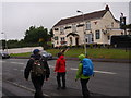
Tafarn Lewis Arms
Cerddwyr yn mynd heibio i Dafarn y Lewis Arms.
Walkers passing the Lewis Arms Public House.
Image: © Alan Richards
Taken: 3 Jun 2012
0.07 miles
8
Preserved section of the old Loughor Viaduct
Image: © Gareth James
Taken: 31 May 2014
0.07 miles
9
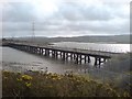
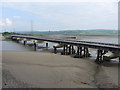
Loughor Railway Bridge
This is where the West Wales Line (and also the Heart of Wales line) crosses the Loughor estuary. The bridge was originally designed by Brunel and built in wood. The design remains but is now rebuilt in metal.
Image: © Hywel Williams
Taken: 10 Mar 2007
0.10 miles