IMAGES TAKEN NEAR TO
Rhandir Terrace, LLANELLI, SA14 8TY
Introduction
This page details the photographs taken nearby to Rhandir Terrace, SA14 8TY by members of the Geograph project.
The Geograph project started in 2005 with the aim of publishing, organising and preserving representative images for every square kilometre of Great Britain, Ireland and the Isle of Man.

There are currently over 7.5m images from over14,400 individuals and you can help contribute to the project by visiting https://www.geograph.org.uk
Image Map
Images are licensed for reuse under creativecommons.org/licenses/by-sa/2.0
Notes
- Clicking on the map will re-center to the selected point.
- The higher the marker number, the further away the image location is from the centre of the postcode.
Image Listing (58 Images Found)
Images are licensed for reuse under creativecommons.org/licenses/by-sa/2.0
Image
Details
Distance
1
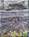
Ordnance Survey Pivot
This OS pivot can be found on No11 Rhandir Terrace, Troeserch Road. It marks a point 13.500m above mean sea level.
Image: © Adrian Dust
Taken: 10 May 2021
0.01 miles
2
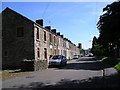
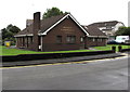
Rhandir Terrace
Looking southwards at these terrace houses with the church Image visible on the higher ground beyond.
Image: © Marion Phillips
Taken: 12 Sep 2009
0.02 miles
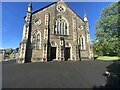
4
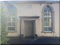
Independent chapel
This chapel was built by Mr Samuel Price of Llanedi, in the year 1831.
Image: © Marion Phillips
Taken: 12 Sep 2009
0.04 miles
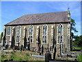
5
Bethesda Capel Bach
The small chapel next to the bigger Bethesda Chapel
Image: © CapG
Taken: 4 Sep 2022
0.04 miles
6
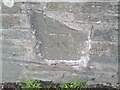
Ordnance Survey Cut Mark
This OS cut mark can be found on the wall NE side of Troserch Road. It marks a point 14.731m above mean sea level.
Image: © Adrian Dust
Taken: 10 May 2021
0.05 miles
7
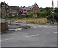
No Entry to Bank Road, Llangennech
Viewed from the corner of Park Lane.
Image: © Jaggery
Taken: 20 Aug 2015
0.08 miles
8
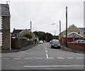
Heol Mwrwg, Llangennech
The eastern end of a long dead-end road which ends at a farm nearly a kilometre ahead.
Image: © Jaggery
Taken: 20 Aug 2015
0.08 miles
9
Llangennech Surgery
Medical surgery in Park Lane.
Image: © Jaggery
Taken: 20 Aug 2015
0.09 miles
10
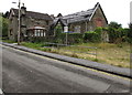
Bank Road, Llangennech
A sign near the wall shows CHURCH PROPERTY - PRIVATE LAND.
The building with part of its roof missing looks like a former hall or perhaps school.
Image: © Jaggery
Taken: 20 Aug 2015
0.10 miles