IMAGES TAKEN NEAR TO
LLANELLI, SA14 8LT
Introduction
This page details the photographs taken nearby to SA14 8LT by members of the Geograph project.
The Geograph project started in 2005 with the aim of publishing, organising and preserving representative images for every square kilometre of Great Britain, Ireland and the Isle of Man.

There are currently over 7.5m images from over14,400 individuals and you can help contribute to the project by visiting https://www.geograph.org.uk
Image Map
Images are licensed for reuse under creativecommons.org/licenses/by-sa/2.0
Notes
- Clicking on the map will re-center to the selected point.
- The higher the marker number, the further away the image location is from the centre of the postcode.
Image Listing (14 Images Found)
Images are licensed for reuse under creativecommons.org/licenses/by-sa/2.0
Image
Details
Distance
1
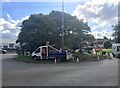
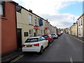
Roundabout near Halfway
Roadworks on roundabout on B4303.
Image: © Alan Hughes
Taken: 7 Sep 2018
0.04 miles
2
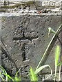
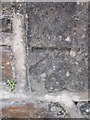
Ordnance Survey Cut Mark
This incomplete OS cut mark can be found on No4 Gors Fach. It marks a point 17.066m above mean sea level.
Image: © Adrian Dust
Taken: 22 Jun 2014
0.08 miles
3
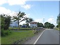
A4138 and roadside signs north of Penceiliogi roundabout
Image: © David Smith
Taken: 2 Jun 2018
0.09 miles
4
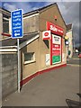
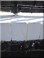
Post Office
Dafen Stores and Post Office.
Image: © Alan Hughes
Taken: 7 Sep 2018
0.10 miles
5
Heol Maescanner / Maescanner Road
Tafarn y Bush yn Heol Maescanner.
The Bush public house in Maescanner Road.
Image: © Alan Richards
Taken: 4 Feb 2018
0.13 miles
6
Ordnance Survey Cut Mark
This OS cut mark can be found on the south parapet of the bridge to the south of the road. It marks a point 12.515m above mean sea level.
Image: © Adrian Dust
Taken: 20 Jul 2014
0.16 miles
7
Ordnance Survey Rivet
This OS rivet can be found on the wall of Bronwydd House. It marks a point 31.099m above mean sea level.
Image: © Adrian Dust
Taken: 22 Jun 2014
0.18 miles
8
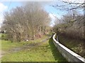
Public Footpath near Dafen
Looking at historic maps, this public footpath started out life as a railway to serve some of the many small coal mines that existed in this area. Today, a small stream runs alongside the footpath.
Image: © Hywel Williams
Taken: 7 Mar 2007
0.18 miles
9
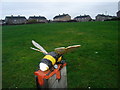
The Bee
One of two public sculptures in Penceiliogi.
Image: © Ronald John Saunders
Taken: 17 Jan 2007
0.19 miles
10
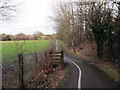
Tuag at Ddafen / Towards Dafen
Llwybr beicio yn mynd i gyfeiriad Dafen.
A cycle path heading in the direction of Dafen.
Image: © Alan Richards
Taken: 30 Jan 2018
0.20 miles