IMAGES TAKEN NEAR TO
Fronhaul, LLANELLI, SA14 8LF
Introduction
This page details the photographs taken nearby to Fronhaul, SA14 8LF by members of the Geograph project.
The Geograph project started in 2005 with the aim of publishing, organising and preserving representative images for every square kilometre of Great Britain, Ireland and the Isle of Man.

There are currently over 7.5m images from over14,400 individuals and you can help contribute to the project by visiting https://www.geograph.org.uk
Image Map
Images are licensed for reuse under creativecommons.org/licenses/by-sa/2.0
Notes
- Clicking on the map will re-center to the selected point.
- The higher the marker number, the further away the image location is from the centre of the postcode.
Image Listing (7 Images Found)
Images are licensed for reuse under creativecommons.org/licenses/by-sa/2.0
Image
Details
Distance
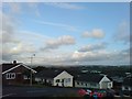
1
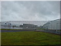
Behind bars - Swiss Valley School
Built in 1970, replacing the old infant and junior schools in Felinfoel. It is in an amazing position with panoramic views sweeping east to west. The nearest building is an extension that did not exist when I was a pupil - we did have a portable cabin though, but it soon became evident that that wouldn't be sufficient for this popular, ever expanding school.
Mr Lewis was the headmaster, Mr Stan Phillips the deputy and some of the other lovely teachers when I was there were Miss Howells and Mr Morgan.
I would have liked to take more photos but in these times I decided it may not be wise to be seen taking photos of a school!
Image: © Deborah Tilley
Taken: 31 Aug 2008
0.15 miles
2
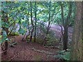
On the site of the old abattoir in Swiss Valley
It is highly unlikely that many, if any of the inhabitants in the area would remember the abattoir that existed here in the late 1960's to early 1970's. The new housing development hadn't extended as far as here and many fields separated the houses and the slaughterhouse. Of course, children being children, as we were back then, knew the area inside out, unlike the adults. I don't remember if it was in use back then but what I do remember is how melancholy the whole area felt.
The abattoir was situated in the area directly behind the place where the community centre is currently situated. It was positioned at the top of a steep slope above the stream, nestled amongst the trees.It was mainly stone built but I recall brick and concrete. There were stalls where the animals would have been housed prior to their demise.
I roughly remembered where it had stood but was disorientated by the surrounding development so was very gratified when looking closer found the remains of wall bases covered with ivy and scattering of plant covered building rubble too big to have come from the building site.
I've looked online for more information, but there is no mention of it. If anyone out there knows the history of the place I'd be very interested to know.
I've classified it as a ruin but it's not even that any more.
Image: © Deborah Tilley
Taken: 31 Aug 2008
0.21 miles
3
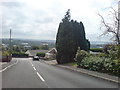
Lofty views
Looking directly at the junction with Lon yr Eglwys. The Loughor Estuary is in the distance and the Gower beyond.
Image: © Deborah Tilley
Taken: 26 Jul 2008
0.22 miles
4
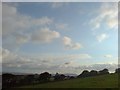
Vista from the next field
Across grass and trees, over Llanelli town down below, dangerously close to sea level and over the Loughor Estuary to Gower.
Image: © Deborah Tilley
Taken: 31 Aug 2008
0.22 miles
5
Pennant Road
It's easier going down than up! There are superb views overland to Glamorgan.
Image: © Deborah Tilley
Taken: 31 Aug 2008
0.23 miles
6
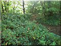
Hidden abattoir
The remains of demolition rubble aren't obvious in the photo but the abattoir building once stood right here.
Image: © Deborah Tilley
Taken: 31 Aug 2008
0.24 miles
7
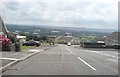
Heol Beili Glas
Looking down the hill to the 'Friendly Rivals' pub (although I think it has now been renamed since being sold).In the distance is the River Loughor and the northern coast of the Gower Peninsula.
Image: © Deborah Tilley
Taken: 26 Jul 2008
0.24 miles