IMAGES TAKEN NEAR TO
Oaklands, LLANELLI, SA14 8DH
Introduction
This page details the photographs taken nearby to Oaklands, SA14 8DH by members of the Geograph project.
The Geograph project started in 2005 with the aim of publishing, organising and preserving representative images for every square kilometre of Great Britain, Ireland and the Isle of Man.

There are currently over 7.5m images from over14,400 individuals and you can help contribute to the project by visiting https://www.geograph.org.uk
Image Map
Images are licensed for reuse under creativecommons.org/licenses/by-sa/2.0
Notes
- Clicking on the map will re-center to the selected point.
- The higher the marker number, the further away the image location is from the centre of the postcode.
Image Listing (14 Images Found)
Images are licensed for reuse under creativecommons.org/licenses/by-sa/2.0
Image
Details
Distance
1
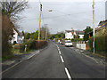
Swiss Valley
Stretch of road in 'Swiss Valley' Llanelli.
Image: © Dara Jasumani
Taken: 31 Mar 2006
0.13 miles
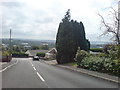
2
Heol Beili Glas
Looking down the hill to the 'Friendly Rivals' pub (although I think it has now been renamed since being sold).In the distance is the River Loughor and the northern coast of the Gower Peninsula.
Image: © Deborah Tilley
Taken: 26 Jul 2008
0.14 miles
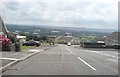
4
Lofty views
Looking directly at the junction with Lon yr Eglwys. The Loughor Estuary is in the distance and the Gower beyond.
Image: © Deborah Tilley
Taken: 26 Jul 2008
0.18 miles
5
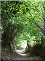
Y Graig
I remember this simple lane, with its stream on one side, as a fabulous green palace filled with nuts in autumn, with masses of bluebells in spring. We used to climb one of the big trees and sit in it for hours. Apparently, there used to be a woman who lived in one of the more modest cottages up there, who appears in one census as a ‘pauper’. And then when you got to the top of the tunnel of trees, and through the rusting black iron wicket gate on the old right of way. There were the brambles on one side and gorse on the other, and the path going straight up to Cribyn Farm – and the much more fascinating one dipping down and over the stream via two great flat stones, and up again to where the carpark opposite the community centre is now.
Then it was just fields. But the real kick was from turning upstream into the huge great green, clean cathedral of trees on either steep mossy ferny bank. Which is still there, only deprived for some municipal reason of its river, and so now has to make do with piles of fly-tipped rubbish.
It does seem obvious why the Baptist Revival was so popular hereabouts during the time when the temples of industrialisation were making many places was very black and smoky. I remember being very young and being carried/dragged by – I think – my sister and cousins across those stepping stones with the water splashing underneath, and assuming that this was the very stream from the nursery rhyme ‘Gi Ceffyl Bach, yn Carrio Ni'n Dau.’:
‘Dwr yn yr afon, a’r cerrig yn slip..’
These were the very stones, my mother knew them, and was making up songs about them for me. At least, that's what I assumed.
They were certainly ‘slip’.
Image: © Rhandir
Taken: 17 Aug 2007
0.18 miles
6
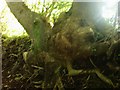
Arborescent alien?
It may be just my fanciful imagination in a reduced light, but this gnarled tree seems to have morphed into an alien life form!
Image: © Deborah Tilley
Taken: 31 Aug 2008
0.20 miles
7
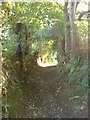
Through the 'fairy glen'
As we knew the area as children. To the right there used to be a stream, since piped in, which was a magnet for us children. We climbed trees and made swings across the water. It was an exciting place to grow up. Sadly the appeal has gone now that the stream has gone. The sense of adventure has been taken away and the area sanitised.
Image: © Deborah Tilley
Taken: 31 Aug 2008
0.21 miles
8

Llwybr Dyffryn y Swisdir / Swiss Valley Path
Cerddwyr yn dilyn Ffordd Sant Illtyd wrth iddo fynd drwy ystad yn Nyffryn y Swisdir.
Walkers following St Illtyd's Way as it goes through an estate in the Swiss Valley.
Image: © Alan Richards
Taken: 11 Feb 2018
0.21 miles
9
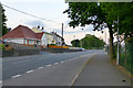
Llethri Road
On the boundary of Felinfoel and Swiss Valley.
Image: © David Lally
Taken: 9 Jun 2013
0.21 miles
10
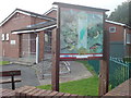
Swiss Valley Community Centre
On the site of a much less posh building in the days when I attended Youth Club here! We didn't need the bars on the doors back then either!
Image: © Deborah Tilley
Taken: 31 Aug 2008
0.22 miles